IMAGES TAKEN NEAR TO
KIRKCALDY, KY2 5XY
Introduction
This page details the photographs taken nearby to KY2 5XY by members of the Geograph project.
The Geograph project started in 2005 with the aim of publishing, organising and preserving representative images for every square kilometre of Great Britain, Ireland and the Isle of Man.

There are currently over 7.5m images from over14,400 individuals and you can help contribute to the project by visiting https://www.geograph.org.uk
Image Map
Images are licensed for reuse under creativecommons.org/licenses/by-sa/2.0
Notes
- Clicking on the map will re-center to the selected point.
- The higher the marker number, the further away the image location is from the centre of the postcode.
Image Listing (8 Images Found)
Images are licensed for reuse under creativecommons.org/licenses/by-sa/2.0
Image
Details
Distance
1
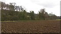
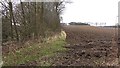
Boglily
A ploughed field on the south side of Boglily Road.
Image: © Richard Webb
Taken: 9 Mar 2012
0.06 miles
3
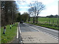
B925 heading past Boglily
The Auchtertool to Kirkcaldy road.
Image: © James Denham
Taken: 26 Apr 2010
0.12 miles
5
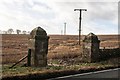
Gateposts opposite the Buffalo Farm, Boglily
There is an Ordnance Survey benchmark on the left-hand post. See Image I assume these posts once marked the entrance to Balwearie Castle.
Image: © Becky Williamson
Taken: 16 Feb 2020
0.14 miles
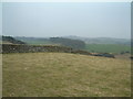
6
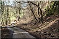
Boglilly Braes
The edge of woodland on a steep scarp, Boglilly Braes.
Image: © Richard Webb
Taken: 9 Mar 2012
0.15 miles
8
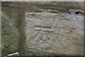
Benchmark on gatepost at Boglily
The gateposts once marked the entrance to Balwearie Castle. Ordnance Survey benchmark, described on database at https://www.bench-marks.org.uk/bm116254. See also Image
Image: © Becky Williamson
Taken: 16 Feb 2020
0.16 miles