IMAGES TAKEN NEAR TO
Camilla Grove, KIRKCALDY, KY2 5XP
Introduction
This page details the photographs taken nearby to Camilla Grove, KY2 5XP by members of the Geograph project.
The Geograph project started in 2005 with the aim of publishing, organising and preserving representative images for every square kilometre of Great Britain, Ireland and the Isle of Man.

There are currently over 7.5m images from over14,400 individuals and you can help contribute to the project by visiting https://www.geograph.org.uk
Image Map
Images are licensed for reuse under creativecommons.org/licenses/by-sa/2.0
Notes
- Clicking on the map will re-center to the selected point.
- The higher the marker number, the further away the image location is from the centre of the postcode.
Image Listing (6 Images Found)
Images are licensed for reuse under creativecommons.org/licenses/by-sa/2.0
Image
Details
Distance
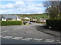
2
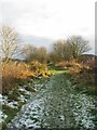
Former Kirkcaldy District Railway line near Auchtertool
Image: © Becky Williamson
Taken: 4 Jan 2021
0.09 miles
3
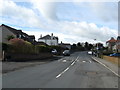
The east end of Auchtertool village
In Fife.
Image: © James Denham
Taken: 26 Apr 2010
0.09 miles
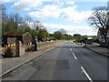
5
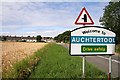
Welcome to Auchtertool
This is the eastern approach to the village on the B925.
Image: © Walter Baxter
Taken: 22 Aug 2011
0.20 miles
6
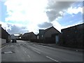
Auchtertool in Fife
Sitting astride the B925.
Image: © James Denham
Taken: 26 Apr 2010
0.23 miles