IMAGES TAKEN NEAR TO
KIRKCALDY, KY2 5XD
Introduction
This page details the photographs taken nearby to KY2 5XD by members of the Geograph project.
The Geograph project started in 2005 with the aim of publishing, organising and preserving representative images for every square kilometre of Great Britain, Ireland and the Isle of Man.

There are currently over 7.5m images from over14,400 individuals and you can help contribute to the project by visiting https://www.geograph.org.uk
Image Map (Loading...)


Getting Data...Please wait
Leaflet Map data © OpenStreetMap
Images are licensed for reuse under creativecommons.org/licenses/by-sa/2.0
Notes
- Clicking on the map will re-center to the selected point.
- The higher the marker number, the further away the image location is from the centre of the postcode.
Image Listing (9 Images Found)
Images are licensed for reuse under creativecommons.org/licenses/by-sa/2.0
Image
Details
Distance
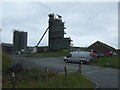
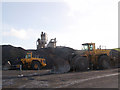
2
Breedon's Orrock Quarry
A large basalt quarry near Burntisland.
Image: © M J Richardson
Taken: 13 Jul 2022
0.03 miles
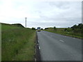
3
The B9157 at Orrock Quarry
A large basalt quarry.
Image: © M J Richardson
Taken: 13 Jul 2022
0.03 miles
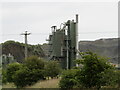
6
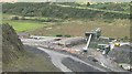
Orrock Quarry
Crushing plant of the quarry from what is left of the ridge of Orrock Hill.
Image: © Richard Webb
Taken: 25 Aug 2008
0.11 miles
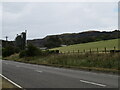
7
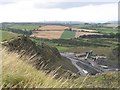
Orrock Hill
Or what is left of it. Most of Orrock Hill's north side is quarried away, but the skyline ridge remains.
Image: © Richard Webb
Taken: 25 Aug 2008
0.14 miles
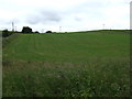
8
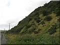
Orrock Hill
The western end of the hill, a steep climb through dense and hostile vegetation which ends suddenly at the edge of the quarry which has grown somewhat since the 1:50,000 map was updated.
Image: © Richard Webb
Taken: 25 Aug 2008
0.21 miles
9
Orrock Quarry
Working basalt quarry with some spectacular columnar jointing.
Image: © John Darcy
Taken: 6 Nov 2005
0.25 miles