IMAGES TAKEN NEAR TO
KIRKCALDY, KY2 5XB
Introduction
This page details the photographs taken nearby to KY2 5XB by members of the Geograph project.
The Geograph project started in 2005 with the aim of publishing, organising and preserving representative images for every square kilometre of Great Britain, Ireland and the Isle of Man.

There are currently over 7.5m images from over14,400 individuals and you can help contribute to the project by visiting https://www.geograph.org.uk
Image Map (Loading...)


Getting Data...Please wait
Leaflet Map data © OpenStreetMap
Images are licensed for reuse under creativecommons.org/licenses/by-sa/2.0
Notes
- Clicking on the map will re-center to the selected point.
- The higher the marker number, the further away the image location is from the centre of the postcode.
Image Listing (3 Images Found)
Images are licensed for reuse under creativecommons.org/licenses/by-sa/2.0
Image
Details
Distance
2
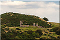
Knockdavie Castle
Knockdavie Castle is the ruin of a small 17th century house, with rubble-built walls. On the North is a semi-circular projection for a turnpike stair.
Image: © John Taylor
Taken: 17 Sep 2015
0.10 miles
3
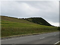
Barley field by the B9157
With pasture and a Gorse-covered hill above.
Image: © M J Richardson
Taken: 13 Jul 2022
0.17 miles