IMAGES TAKEN NEAR TO
KIRKCALDY, KY2 5UL
Introduction
This page details the photographs taken nearby to KY2 5UL by members of the Geograph project.
The Geograph project started in 2005 with the aim of publishing, organising and preserving representative images for every square kilometre of Great Britain, Ireland and the Isle of Man.

There are currently over 7.5m images from over14,400 individuals and you can help contribute to the project by visiting https://www.geograph.org.uk
Image Map
Images are licensed for reuse under creativecommons.org/licenses/by-sa/2.0
Notes
- Clicking on the map will re-center to the selected point.
- The higher the marker number, the further away the image location is from the centre of the postcode.
Image Listing (3 Images Found)
Images are licensed for reuse under creativecommons.org/licenses/by-sa/2.0
Image
Details
Distance
1
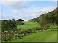
Kirkcaldy Golf Course, 5th Hole, Railway
The view from the tee on the long fifth hole at Kirkcaldy, looking down on the fairway, with the green on top of the hill just left of centre.
Image: © Scott Cormie
Taken: 11 Oct 2019
0.20 miles
2
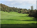
Kirkcaldy Golf Course, 8th Hole, Middle Burn
The view from the eighth tee at Kirkcaldy, looking to the green, with the burn running all the way down the right.
Image: © Scott Cormie
Taken: 11 Oct 2019
0.20 miles
3
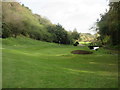
Kirkcaldy Golf Course, 7th Hole, Short Burn
The short seventh hole at Kirkcaldy from short of the green, with the burn to the right.
Image: © Scott Cormie
Taken: 11 Oct 2019
0.24 miles