IMAGES TAKEN NEAR TO
Winifred Crescent, KIRKCALDY, KY2 5SY
Introduction
This page details the photographs taken nearby to Winifred Crescent, KY2 5SY by members of the Geograph project.
The Geograph project started in 2005 with the aim of publishing, organising and preserving representative images for every square kilometre of Great Britain, Ireland and the Isle of Man.

There are currently over 7.5m images from over14,400 individuals and you can help contribute to the project by visiting https://www.geograph.org.uk
Image Map (Loading...)


Getting Data...Please wait
Leaflet Map data © OpenStreetMap
Images are licensed for reuse under creativecommons.org/licenses/by-sa/2.0
Notes
- Clicking on the map will re-center to the selected point.
- The higher the marker number, the further away the image location is from the centre of the postcode.
Image Listing (2 Images Found)
Images are licensed for reuse under creativecommons.org/licenses/by-sa/2.0
Image
Details
Distance
1
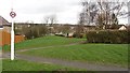
Path off Benarty Street
A strip of land which was not built upon during the expansion of Kirkcaldy.
Image: © Richard Webb
Taken: 9 Mar 2012
0.05 miles
2
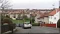
Benarty Street
Residential area, Kirkcaldy.
Image: © Richard Webb
Taken: 9 Mar 2012
0.10 miles