IMAGES TAKEN NEAR TO
Winifred Street, KIRKCALDY, KY2 5SR
Introduction
This page details the photographs taken nearby to Winifred Street, KY2 5SR by members of the Geograph project.
The Geograph project started in 2005 with the aim of publishing, organising and preserving representative images for every square kilometre of Great Britain, Ireland and the Isle of Man.

There are currently over 7.5m images from over14,400 individuals and you can help contribute to the project by visiting https://www.geograph.org.uk
Image Map (Loading...)


Getting Data...Please wait
Leaflet Map data © OpenStreetMap
Images are licensed for reuse under creativecommons.org/licenses/by-sa/2.0
Notes
- Clicking on the map will re-center to the selected point.
- The higher the marker number, the further away the image location is from the centre of the postcode.
Image Listing (8 Images Found)
Images are licensed for reuse under creativecommons.org/licenses/by-sa/2.0
Image
Details
Distance
1
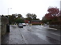
Rear of Forth Park Hospital
The former maternity hospital closed on January 9, 2012. Planning in principal is approved for demolition of many of the buildings on the site, with redevelopment of the site for housing.
Image: © Richard Dorrell
Taken: 23 Nov 2015
0.14 miles
2
Former Forth Park Maternity Hospital, Kirkcaldy
Image: © Douglas Nelson
Taken: 10 Oct 2012
0.16 miles
3
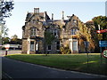
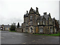
Forth Park Mansion
Built circa 1860, with later additions. The mansion was the home of linoleum manufacturer Daniel Hendry from 1875 to his death in 1893. In 1934 the house and grounds were gifted to the town by Mrs R Wemyss Honeyman (daughter of John Nairn) of Westdean. The subsequent conversion to administration block with nearby newly built maternity hospital was carried out by William Williamson at a cost of £12,000, and officially opened on 23rd November, 1935. The Mansion House admin block was closed in September 2001 over concerns about its structural stability. The Forth Park Hospital itself closed on Monday, January 9, 2012. Planning Permission in Principal for a residential development on the site of the former hospital, including the conversion of the mansion house and associated stables, was conditionally approved Aug 2011. However, in spite of being Category B listed, the Mansion House is not being maintained and is now listed on the Buildings at Risk Register for Scotland as in 'very poor' condition and at 'high risk'.
Another view: Image
Stables: Image
Image: © Richard Dorrell
Taken: 23 Nov 2015
0.16 miles
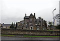
4
Forth Park Mansion
The Category B listed building has been disused since September 2001, and has been allowed to decay to a dangerous state. For another view and more history, see: Image
Image: © Richard Dorrell
Taken: 23 Nov 2015
0.16 miles
5
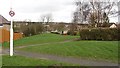
Path off Benarty Street
A strip of land which was not built upon during the expansion of Kirkcaldy.
Image: © Richard Webb
Taken: 9 Mar 2012
0.18 miles
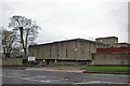
6
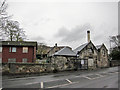
Former stable block
The stone building is the former stable block of Forth Park Mansion. (See Image]). The building is Grade B listed. It was incorporated into the Forth Park Maternity Hospital, which closed in January 2012, and has remained derelict since. Permission now exists for redevelopment of the site for housing.
Image: © Richard Dorrell
Taken: 23 Nov 2015
0.20 miles
7
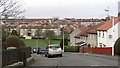
Benarty Street
Residential area, Kirkcaldy.
Image: © Richard Webb
Taken: 9 Mar 2012
0.22 miles