IMAGES TAKEN NEAR TO
Sauchenbush Road, KIRKCALDY, KY2 5RN
Introduction
This page details the photographs taken nearby to Sauchenbush Road, KY2 5RN by members of the Geograph project.
The Geograph project started in 2005 with the aim of publishing, organising and preserving representative images for every square kilometre of Great Britain, Ireland and the Isle of Man.

There are currently over 7.5m images from over14,400 individuals and you can help contribute to the project by visiting https://www.geograph.org.uk
Image Map (5 Images)


Getting Data...Please wait
Leaflet Map data © OpenStreetMap
Images are licensed for reuse under creativecommons.org/licenses/by-sa/2.0
Notes
- Clicking on the map will re-center to the selected point.
- The higher the marker number, the further away the image location is from the centre of the postcode.
Image Listing (5 Images Found)
Images are licensed for reuse under creativecommons.org/licenses/by-sa/2.0
Image
Details
Distance
1
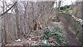
Woodland, Kirkcaldy
A steep wooded slope beneath Sauchenbush Road.
Image: © Richard Webb
Taken: 9 Mar 2012
0.11 miles
2
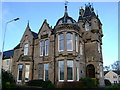
Beechwood, Kirkcaldy
This is Beechwood in Bennochy Road, Kirkcaldy. The house was built in 1880 for Michael Beveridge (provost of Kirkcaldy) who lived in the property until his sudden death from pneumonia in 1890. Later, ownership changed to the Kirkcaldy branch of the royal legion. In 1993, the house was made a Category B listed building, saving Beechwood from demolition. Nowadays, the house has been converted into two flats with some new houses built behind in the grounds.
Image: © Ian Thomson
Taken: 13 Jan 2009
0.16 miles
3
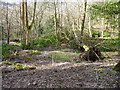
Windblown tree
In the Long Braes plantation, Kirkcaldy.
Image: © James Allan
Taken: 22 Feb 2016
0.18 miles
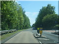
5
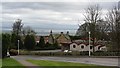
Bennochy Road
A fine view of the Forth from a residential area of Kirkcaldy.
Image: © Richard Webb
Taken: 9 Mar 2012
0.22 miles