IMAGES TAKEN NEAR TO
Harcourt Road, KIRKCALDY, KY2 5HQ
Introduction
This page details the photographs taken nearby to Harcourt Road, KY2 5HQ by members of the Geograph project.
The Geograph project started in 2005 with the aim of publishing, organising and preserving representative images for every square kilometre of Great Britain, Ireland and the Isle of Man.

There are currently over 7.5m images from over14,400 individuals and you can help contribute to the project by visiting https://www.geograph.org.uk
Image Map
Images are licensed for reuse under creativecommons.org/licenses/by-sa/2.0
Notes
- Clicking on the map will re-center to the selected point.
- The higher the marker number, the further away the image location is from the centre of the postcode.
Image Listing (11 Images Found)
Images are licensed for reuse under creativecommons.org/licenses/by-sa/2.0
Image
Details
Distance
1
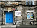
Entrance to Kirkcaldy North Primary School
Image: © Alex McGregor
Taken: 30 Nov 2013
0.12 miles
2
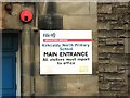
Entrance to Kirkcaldy North Primary School
Image: © Alex McGregor
Taken: 30 Nov 2013
0.13 miles
3
Rear of Forth Park Hospital
The former maternity hospital closed on January 9, 2012. Planning in principal is approved for demolition of many of the buildings on the site, with redevelopment of the site for housing.
Image: © Richard Dorrell
Taken: 23 Nov 2015
0.19 miles
4
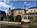
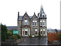
Victoria Hotel
Hotel on Victoria Road formerly the home of celebrated furniture manufacturer AH McIntosh
Image: © Graham Hogg
Taken: 12 Oct 2019
0.19 miles
5
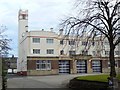
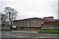
Art deco Fire station
Built in the 1930s, Kirkcaldy's Fire station in Dunnikier Road has a distinctive art deco appearance.
Image: © James Allan
Taken: 17 Feb 2009
0.20 miles
7
Legion Court
A cul-de-sac off Bennochy Road.
Image: © James Allan
Taken: 17 Feb 2009
0.21 miles
8
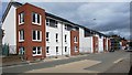
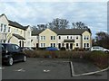
New housing development, Kirkcaldy
Still under construction this new housing development in Victoria Road is being built on the site of a former Vauxhall Motors dealership.
Image: © Bill Kasman
Taken: 30 Jul 2017
0.22 miles
9
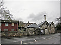
Former stable block
The stone building is the former stable block of Forth Park Mansion. (See Image]). The building is Grade B listed. It was incorporated into the Forth Park Maternity Hospital, which closed in January 2012, and has remained derelict since. Permission now exists for redevelopment of the site for housing.
Image: © Richard Dorrell
Taken: 23 Nov 2015
0.22 miles