IMAGES TAKEN NEAR TO
Hayfield Place, Hayfield Industrial Estate, KIRKCALDY, KY2 5DH
Introduction
This page details the photographs taken nearby to Hayfield Place, Hayfield Industrial Estate, KY2 5DH by members of the Geograph project.
The Geograph project started in 2005 with the aim of publishing, organising and preserving representative images for every square kilometre of Great Britain, Ireland and the Isle of Man.

There are currently over 7.5m images from over14,400 individuals and you can help contribute to the project by visiting https://www.geograph.org.uk
Image Map
Images are licensed for reuse under creativecommons.org/licenses/by-sa/2.0
Notes
- Clicking on the map will re-center to the selected point.
- The higher the marker number, the further away the image location is from the centre of the postcode.
Image Listing (14 Images Found)
Images are licensed for reuse under creativecommons.org/licenses/by-sa/2.0
Image
Details
Distance
1
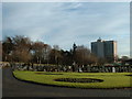
Kirkcaldy : Hayfield Cemetery
Photograph taken in Hayfield Cemetery looking towards Victoria Hospital and Middle den Wood
Image: © Kevin O'Kane
Taken: 21 Dec 2005
0.14 miles
2

The Den Burn
A ford used by a mountain bike track.
Image: © Richard Webb
Taken: 9 Mar 2012
0.14 miles
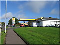
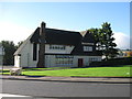
4
Templehall Avenue, Hendry Road, Kirkcaldy
Image: © Alex McGregor
Taken: 8 Jun 2011
0.19 miles
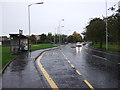
6
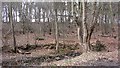
Middle Den
A fine piece of woodland inside Kirkcaldy.
Image: © Richard Webb
Taken: 9 Mar 2012
0.20 miles

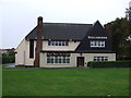
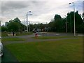
10
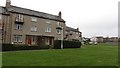
Flats, Hendry Road
There is quite a lot of informal green space in this residential area.
Image: © Richard Webb
Taken: 9 Mar 2012
0.22 miles