IMAGES TAKEN NEAR TO
Greenhill Road, ST. ANDREWS, KY16 9ZU
Introduction
This page details the photographs taken nearby to Greenhill Road, KY16 9ZU by members of the Geograph project.
The Geograph project started in 2005 with the aim of publishing, organising and preserving representative images for every square kilometre of Great Britain, Ireland and the Isle of Man.

There are currently over 7.5m images from over14,400 individuals and you can help contribute to the project by visiting https://www.geograph.org.uk
Image Map
Images are licensed for reuse under creativecommons.org/licenses/by-sa/2.0
Notes
- Clicking on the map will re-center to the selected point.
- The higher the marker number, the further away the image location is from the centre of the postcode.
Image Listing (13 Images Found)
Images are licensed for reuse under creativecommons.org/licenses/by-sa/2.0
Image
Details
Distance
3
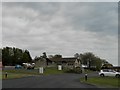
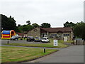
Clayton Restaurant
At the entrance to Clayton Caravan Park.
Image: © James Allan
Taken: 25 Aug 2014
0.08 miles
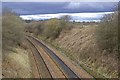
6
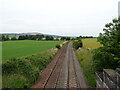
Railway towards Leuchars
Looking north from the bridge on the A91.
Image: © JThomas
Taken: 23 Jul 2021
0.18 miles
7
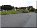
Railway, Dron & Clayton
The railway between Dundee and Edinburgh via the Tay and Forth Bridges.
Image: © Richard Webb
Taken: 6 Dec 2014
0.18 miles
8
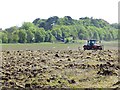
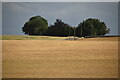
Working ground
Field being prepared for a crop and a feast for the gulls.
Image: © Richard Webb
Taken: 24 May 2013
0.18 miles
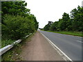
9
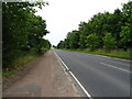
A91 towards Guardbridge
Crossing the Edinburgh to Aberdeen railway.
Image: © JThomas
Taken: 23 Jul 2021
0.19 miles
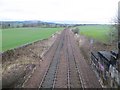
10
Clayton cutting
South from the bridge with the cruve leading toward Dron and Cupar.
Image: © Jim Bain
Taken: 18 Mar 2008
0.19 miles