IMAGES TAKEN NEAR TO
Sunnyside, ST. ANDREWS, KY16 9XP
Introduction
This page details the photographs taken nearby to Sunnyside, KY16 9XP by members of the Geograph project.
The Geograph project started in 2005 with the aim of publishing, organising and preserving representative images for every square kilometre of Great Britain, Ireland and the Isle of Man.

There are currently over 7.5m images from over14,400 individuals and you can help contribute to the project by visiting https://www.geograph.org.uk
Image Map
Images are licensed for reuse under creativecommons.org/licenses/by-sa/2.0
Notes
- Clicking on the map will re-center to the selected point.
- The higher the marker number, the further away the image location is from the centre of the postcode.
Image Listing (52 Images Found)
Images are licensed for reuse under creativecommons.org/licenses/by-sa/2.0
Image
Details
Distance
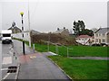
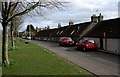
2
Cottages on Church Road, Strathkinness
Image: © Richard Sutcliffe
Taken: 19 Mar 2019
0.06 miles
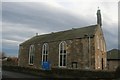
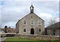
3
Strathkinness Parish Church
In the distance is the village hall.
Image: © Richard Sutcliffe
Taken: 19 Mar 2019
0.06 miles
4
Cottages on Church Road, Strathkinness
Image: © Richard Sutcliffe
Taken: 19 Mar 2019
0.06 miles
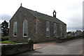
5
Strathkinness Parish Church
On Church Road.
Image: © Richard Sutcliffe
Taken: 19 Mar 2019
0.07 miles
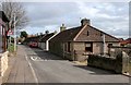
6
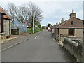
Church Road, Strathkinness
Looking north-eastward.
Image: © Peter Wood
Taken: 9 May 2021
0.07 miles
7
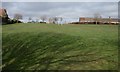
Recreation ground, Strathkinness
Seen from beside Church Road.
Image: © Richard Sutcliffe
Taken: 19 Mar 2019
0.08 miles
8

Houses at junction of Church Road and Sunnyside
Image: © Richard Sutcliffe
Taken: 19 Mar 2019
0.08 miles