IMAGES TAKEN NEAR TO
Fife Park, Strathkinness High Road, ST. ANDREWS, KY16 9UE
Introduction
This page details the photographs taken nearby to Fife Park, Strathkinness High Road, KY16 9UE by members of the Geograph project.
The Geograph project started in 2005 with the aim of publishing, organising and preserving representative images for every square kilometre of Great Britain, Ireland and the Isle of Man.

There are currently over 7.5m images from over14,400 individuals and you can help contribute to the project by visiting https://www.geograph.org.uk
Image Map
Images are licensed for reuse under creativecommons.org/licenses/by-sa/2.0
Notes
- Clicking on the map will re-center to the selected point.
- The higher the marker number, the further away the image location is from the centre of the postcode.
Image Listing (11 Images Found)
Images are licensed for reuse under creativecommons.org/licenses/by-sa/2.0
Image
Details
Distance
1
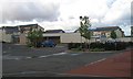
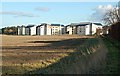
David Russel Hall
Student and in the Summer, tourist accommodation. Built on the site of David Russell Hall.
Image: © Richard Webb
Taken: 12 Aug 2009
0.02 miles
2
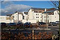
David Russell Halls
The newly built 2002/04 David Russell Halls on the Western edge of town and major part of the university's accommodation stock in the town.
Image: © Jim Bain
Taken: 17 Feb 2007
0.04 miles
3
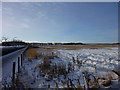
David Russell Hall
Looking across the fields toward David Russell Hall.
Image: © I A Smellie
Taken: 20 Dec 2010
0.05 miles
4
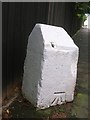
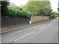
Old Milestone by the B939, west of St Andrews
Milestone by the B939, in parish of St Andrews (Fife District), Strathkinness Low Road, West of junction with Strathkiness High road and David Russell University buildings.
Inscription once read:-
: (St Andrews 1) : : (Ceres 6¾) :
Carved bench mark on East face.
Surveyed
Milestone Society National ID: FF_SACE01
Image: © Milestone Society
Taken: Unknown
0.08 miles
5
Milestone on Strathkinness Low Road
Milestone near the junction of the Strathkinness High and Low roads on the west side of St.Andrews.
Image: © Scott Cormie
Taken: 12 Aug 2017
0.08 miles
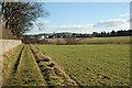
6
By North Bank Farm
The path linking the Guardbridge/St Andrews road and the Strathkinness/St Andrews road. Looking back across the field towards the North side of the David Russell Halls just inside the next square.
Image: © Jim Bain
Taken: 17 Feb 2007
0.11 miles
7
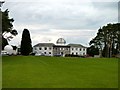
St Andrews University Observatory
The Scott Lang building is the most prominent building seen here. It houses a research group from the School of Mathematics and Statistics and the dome houses a 50-cm telescope plus spectrograph and CCD detector.
Image: © James Allan
Taken: 23 Mar 2011
0.15 miles
8
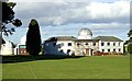
University Observatory
St Andrews Observatory was founded in 1962. The large building to the right of shot is the Scott Lang building with the smaller buildings to the left housing other scopes used for research.
Image: © Jim Bain
Taken: 17 Feb 2007
0.19 miles
9
By Balgove
The path linking the Guardbridge/St Andrews road and the Strathkinness/St Andrews road. Looking towards St Andrews from near Balgove
Image: © Jim Bain
Taken: 17 Feb 2007
0.20 miles
