IMAGES TAKEN NEAR TO
Lade Braes, ST. ANDREWS, KY16 9ES
Introduction
This page details the photographs taken nearby to Lade Braes, KY16 9ES by members of the Geograph project.
The Geograph project started in 2005 with the aim of publishing, organising and preserving representative images for every square kilometre of Great Britain, Ireland and the Isle of Man.

There are currently over 7.5m images from over14,400 individuals and you can help contribute to the project by visiting https://www.geograph.org.uk
Image Map
Images are licensed for reuse under creativecommons.org/licenses/by-sa/2.0
Notes
- Clicking on the map will re-center to the selected point.
- The higher the marker number, the further away the image location is from the centre of the postcode.
Image Listing (322 Images Found)
Images are licensed for reuse under creativecommons.org/licenses/by-sa/2.0
Image
Details
Distance
1
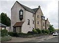
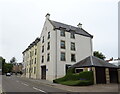
John Coupar Court
Off Bridge Street, St Andrews.
Image: © Richard Sutcliffe
Taken: 21 May 2019
0.03 miles
2
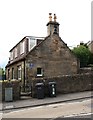
New York Cottage, Bridge Street, St Andrews
The home of Thomas Rodger, pioneer of photography in St Andrews.
Image: © Richard Sutcliffe
Taken: 21 May 2019
0.04 miles
3
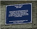
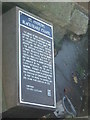
Plaque commemorating Thomas Rodger
Plaque on the wall of New York Cottage https://www.geograph.org.uk/photo/6168335 commemorating Thomas Rodger. It reads:
Thomas Rodger
1832-1883
Thomas Rodger took his first photographs here
in the garden of New York Cottage. He became
renowned as a pioneer of photography in
St Andrews. There is another plaque with further
information about him outside what was his studio
in St Mary's Place.
Erected by the St Andrews Preservation Trust
Gordon Christie Bequest
See https://www.geograph.org.uk/photo/1041532 for a view of the house and studio.
Image: © Richard Sutcliffe
Taken: 21 May 2019
0.04 miles
4
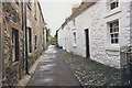
Loudens Close, St Andrews
Looking north to South Street through the portal. This is the widest part of the close.
Image: © Jim Bain
Taken: 1 Apr 2006
0.04 miles
5
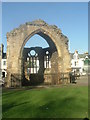
Ruins of Blackfriars' Chapel
St Andrews
Image: © Stanley Howe
Taken: 27 Oct 2005
0.04 miles
7
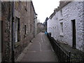
Loudens Close
The view of Loudens Close after having gone through the open entrance to the close from South Street Image
Image: © Sandy Gemmill
Taken: 19 Feb 2007
0.04 miles
8
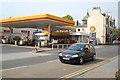
Westport filling stations
The Shell fuel station and the Whey Pat pub by the West Port. I am standing on the site of another fuel station. It closed a few years back and is now posh flats.
The relentless march of the supermarket filling stations mean that these are now an endangered feature of the urban landscape. This is the last one in St Andrews and for at least 8 miles in any direction.
Image: © Jim Bain
Taken: 5 May 2007
0.04 miles
10
Louden's Close
Looking south from the entrance off South Street.
Image: © Richard Sutcliffe
Taken: Unknown
0.05 miles