IMAGES TAKEN NEAR TO
Hillwood Industrial Estate, ST. ANDREWS, KY16 8TR
Introduction
This page details the photographs taken nearby to Hillwood Industrial Estate, KY16 8TR by members of the Geograph project.
The Geograph project started in 2005 with the aim of publishing, organising and preserving representative images for every square kilometre of Great Britain, Ireland and the Isle of Man.

There are currently over 7.5m images from over14,400 individuals and you can help contribute to the project by visiting https://www.geograph.org.uk
Image Map
Images are licensed for reuse under creativecommons.org/licenses/by-sa/2.0
Notes
- Clicking on the map will re-center to the selected point.
- The higher the marker number, the further away the image location is from the centre of the postcode.
Image Listing (16 Images Found)
Images are licensed for reuse under creativecommons.org/licenses/by-sa/2.0
Image
Details
Distance
1
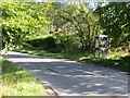
Telephone box, Lathockar
Still active (2013).
Image: © Richard Webb
Taken: 8 Sep 2013
0.06 miles
2
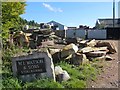
W.L. Watson & Sons
Stonemason's yard, Lathockar.
Image: © Richard Webb
Taken: 8 Sep 2013
0.06 miles
3
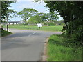
C41 and A915 junction
The C41 (Fife) road meeting the A915 near Lathockar.
Image: © Scott Cormie
Taken: 30 May 2023
0.07 miles
4
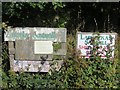
Signs, Lathockar
A couple of signs to the sawmill. There is also a stonemason's yard nearby.
Image: © Richard Webb
Taken: 8 Sep 2013
0.07 miles
5
Water tower
Off a minor road near Lathockar this curious-looking structure is actually a rather old water tower http://bwtas.blogspot.com/2017/02/lathockar-water-tower-restored.html It was restored and renovated in 2017 as part of a residential development being constructed.
Image: © Bill Kasman
Taken: 28 Apr 2018
0.07 miles
6
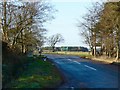
Lathockar Road Junction
Where the minor road from Stravithie joins the A915.
Image: © James Allan
Taken: 26 Jan 2009
0.08 miles
7
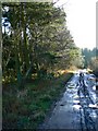
Muddy track
Leading about 750 metres southwards through woodland from near Lathockar road junction to a dead end.
Image: © James Allan
Taken: 26 Jan 2009
0.08 miles
8
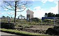
Road and housing development near to Lathockar
Looking north-westward.
Image: © Peter Wood
Taken: 12 May 2021
0.10 miles
9
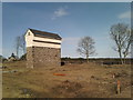
Modern-looking water tower
The Lathockar water tower is not new, but actually over a century old. Originally erected to supply water to Lathockar estate and manor house, it was renovated in 2016 by the construction company building a new residential housing estate alongside it.
Image: © James Allan
Taken: 6 Apr 2017
0.10 miles
10
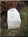
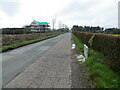
Milestone and bench mark, Hazeldene
For a wider view Image
Milestones did not come into general use until the Turnpike Act of 1766 made them compulsory on turnpike roads, these roads were built by private enterprise under licence from the Government and maintained by tolls on those who used them. Before this Act milestones were put up occasionally, often as charitable acts and commemorations. Many Turnpike Act stones still exist. They are usually 2-3 ft high, with the initial letter or abbreviation of the nearest market town show on two faces, and the distance from it.
Lots of information about the bench mark at
A bench mark is an Ordnance Survey arrowhead sign found on walls, bridges, churches and specially erected triangulation pillars where the altitude above sea-level has been accurately measured by surveyors. The arrowhead points to a horizontal line above it which marks the exact altitude.
With rivets and pivots there is no datum (horizontal line) cut, the pointed-to horizontal surface defining the datum height.
Image: © Maigheach-gheal
Taken: 4 Apr 2010
0.15 miles