IMAGES TAKEN NEAR TO
Torrie Wynd, ST. ANDREWS, KY16 8TE
Introduction
This page details the photographs taken nearby to Torrie Wynd, KY16 8TE by members of the Geograph project.
The Geograph project started in 2005 with the aim of publishing, organising and preserving representative images for every square kilometre of Great Britain, Ireland and the Isle of Man.

There are currently over 7.5m images from over14,400 individuals and you can help contribute to the project by visiting https://www.geograph.org.uk
Image Map
Images are licensed for reuse under creativecommons.org/licenses/by-sa/2.0
Notes
- Clicking on the map will re-center to the selected point.
- The higher the marker number, the further away the image location is from the centre of the postcode.
Image Listing (66 Images Found)
Images are licensed for reuse under creativecommons.org/licenses/by-sa/2.0
Image
Details
Distance
1
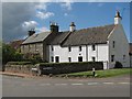
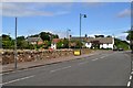
Station Road / Torrie Wynd - Kingsbarns
The now dismantled railway to St Andrews passed within a mile of Kingsbarns, hence the "Station Road" street name.
Image: © Callum Black
Taken: 6 May 2007
0.02 miles
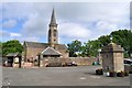
2
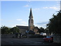
Kingsbarns Steeple
The steeple and parish church at Kingsbarns.
Image: © Scott Cormie
Taken: 31 Jul 2018
0.02 miles
3
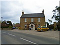
The Barns at Kingsbarns
A modern boutique hotel and bar beside the A917.
Image: © Maigheach-gheal
Taken: 14 Apr 2011
0.02 miles
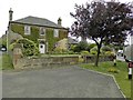
4
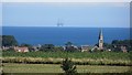
Kingsbarns
A view from near the site of the Dunino Airfield. The platform has been anchored off the mouth of the Firth of Forth for some time.
Image: © Richard Webb
Taken: 8 Sep 2013
0.02 miles
6
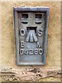
Flush Bracket G4280, Kingsbarns
The Ordnance Survey flush bracket is to be found on the north west angle of the building. For a wider view of the building Image and for further information on the flush bracket and others in the area http://www.bench-marks.org.uk/bm448
Image: © Maigheach-gheal
Taken: 14 Apr 2011
0.03 miles
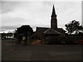
7
Kingsbarns Parish Church
The original building dates from around 1630, and was substantially reworked around 1810. On the right is the village pump.
Image: © Robert Struthers
Taken: 17 Jun 2017
0.03 miles
9
Main Street, Kingsbarns
Otherwise known as the A917, which takes the long way round from St Andrews to Upper Largo.
Image: © Robert Struthers
Taken: 17 Jun 2017
0.03 miles
10
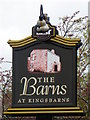
Sign for the Barns at Kingsbarns
This is the sign for the hotel featured in Image
Image: © Maigheach-gheal
Taken: 14 Apr 2011
0.03 miles