IMAGES TAKEN NEAR TO
ST. ANDREWS, KY16 8QG
Introduction
This page details the photographs taken nearby to KY16 8QG by members of the Geograph project.
The Geograph project started in 2005 with the aim of publishing, organising and preserving representative images for every square kilometre of Great Britain, Ireland and the Isle of Man.

There are currently over 7.5m images from over14,400 individuals and you can help contribute to the project by visiting https://www.geograph.org.uk
Image Map
Images are licensed for reuse under creativecommons.org/licenses/by-sa/2.0
Notes
- Clicking on the map will re-center to the selected point.
- The higher the marker number, the further away the image location is from the centre of the postcode.
Image Listing (4 Images Found)
Images are licensed for reuse under creativecommons.org/licenses/by-sa/2.0
Image
Details
Distance
1
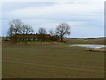
Casual water
A temporary rainwater pond in a hollow beside Drumly farm.
Image: © James Allan
Taken: 16 Feb 2009
0.03 miles
2
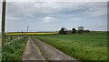
Track to Drumly
This track leads from Station Road to Drumly.
Image: © Kathrin Passig
Taken: 15 May 2022
0.04 miles
3
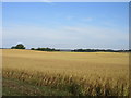
Field of oats
Oat field between Drumly and Swinkie.
Image: © Scott Cormie
Taken: 31 Jul 2018
0.21 miles
4
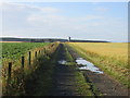
Track to Sunnybraes
The track heading south to Sunnybraes in the distance.
Image: © Scott Cormie
Taken: 31 Jul 2018
0.22 miles