IMAGES TAKEN NEAR TO
Boarhills, ST. ANDREWS, KY16 8PT
Introduction
This page details the photographs taken nearby to KY16 8PT by members of the Geograph project.
The Geograph project started in 2005 with the aim of publishing, organising and preserving representative images for every square kilometre of Great Britain, Ireland and the Isle of Man.

There are currently over 7.5m images from over14,400 individuals and you can help contribute to the project by visiting https://www.geograph.org.uk
Image Map
Images are licensed for reuse under creativecommons.org/licenses/by-sa/2.0
Notes
- Clicking on the map will re-center to the selected point.
- The higher the marker number, the further away the image location is from the centre of the postcode.
Image Listing (10 Images Found)
Images are licensed for reuse under creativecommons.org/licenses/by-sa/2.0
Image
Details
Distance
1
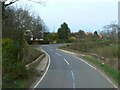
Kenley Bridge
Bridge carrying the A917 over the Kenley Water.
Image: © James Allan
Taken: 1 Apr 2009
0.05 miles
2
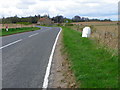
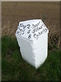
Milestone near Boarhills
The milestone stands beside the A917 and it has an Ordnance Survey benchmark on it.
Milestones are the original roadside heritage features with many dating back hundreds of years and these historic items are under threat from highway developments.
Image: © Maigheach-gheal
Taken: 14 Apr 2011
0.16 miles
3
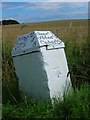
Milestone and bench mark, Falside
The Ordnance Survey bench mark is to be found on the side of the milestone beside the A917. For a wider view of the stone Image and for further information on the cut mark and others in the area http://www.bench-marks.org.uk/bm38189
Image: © Maigheach-gheal
Taken: 14 Apr 2011
0.16 miles
4
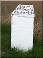
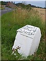
Milestone near Boarhills
For a wider view of the milestone Image
Milestones did not come into general use until the Turnpike Act of 1766 made them compulsory on turnpike roads, these roads were built by private enterprise under licence from the Government and maintained by tolls on those who used them. Before this Act milestones were put up occasionally, often as charitable acts and commemorations. Many Turnpike Act stones still exist. They are usually 2-3 ft high, with the initial letter or abbreviation of the nearest market town shown on two faces, and the distance from it.
Image: © Maigheach-gheal
Taken: 14 Apr 2011
0.16 miles
5
Old Milestone by the A917, Falside, Kingsbarns Parish
A stone post with metal cap by the A917, in parish of Kingsbarns (Fife District), Falside, on left hand bend.
Surveyed
Milestone Society National ID: FF_SACR05.
Image: © Milestone Society
Taken: Unknown
0.16 miles
6
Milestone, Falside
The roads of Fife are peppered with attractively-lettered milestones. This is a mile towards St Andrews from Image In the background, by the A917, are Falside Farm Cottages, from where a path runs down to join the coast path by Kenly Water.
Image: © Derek Harper
Taken: 15 Aug 2008
0.16 miles
7
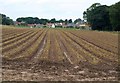
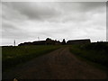
Field, Boarhills
A similar view to Image, taken from further east, looking along lines of stubble from the A917.
Image: © Derek Harper
Taken: 15 Aug 2008
0.18 miles
8
Disused railway tunnel on Crail - St Andrews Line
The tunnel is situated south of Boarhills.
Image: © Becky Williamson
Taken: 8 Mar 2020
0.20 miles
9

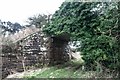
Disused railway bridge
The view of a farm track going under a disused railway bridge. The disused railway is overgrown and in summer it is not easy terrain on which to walk.
Image: © Sandy Gemmill
Taken: 2 Aug 2016
0.20 miles