IMAGES TAKEN NEAR TO
Boarhills, ST. ANDREWS, KY16 8PS
Introduction
This page details the photographs taken nearby to KY16 8PS by members of the Geograph project.
The Geograph project started in 2005 with the aim of publishing, organising and preserving representative images for every square kilometre of Great Britain, Ireland and the Isle of Man.

There are currently over 7.5m images from over14,400 individuals and you can help contribute to the project by visiting https://www.geograph.org.uk
Image Map
Images are licensed for reuse under creativecommons.org/licenses/by-sa/2.0
Notes
- Clicking on the map will re-center to the selected point.
- The higher the marker number, the further away the image location is from the centre of the postcode.
Image Listing (7 Images Found)
Images are licensed for reuse under creativecommons.org/licenses/by-sa/2.0
Image
Details
Distance
1
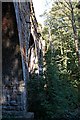
Kenly Viaduct
A disused viaduct over the Kenly Water on the old St Andrews to Thornton railway line. Now very hidden from view but this is an impressive viaduct for such a small railway line and must have cost a considerable percentage of the construction budget in its day. Will come back in the spring before the leaf.
Image: © Jim Bain
Taken: 1 Sep 2006
0.05 miles
2
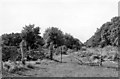
Site of Boarhills Station
View westward, towards St Andrews; ex-NBR Thornton Junction - Crail - St Andrews line. This station closed to passengers 22/9/30, but not to goods until 5/10/64; the line was closed completely 6/9/65.
Image: © Ben Brooksbank
Taken: 19 Sep 1974
0.09 miles
3
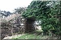
By Kenly
A disused bridge over a farm road on the old St Andrews to Thornton railway line. It seems the farm road is going the way of the railway and falling out of use probably because modern farm tractors and implements can not get under the lowish brig.
Image: © Jim Bain
Taken: 1 Sep 2006
0.12 miles
4

Disused railway bridge
The view of a farm track going under a disused railway bridge. The disused railway is overgrown and in summer it is not easy terrain on which to walk.
Image: © Sandy Gemmill
Taken: 2 Aug 2016
0.18 miles
5
Disused railway tunnel on Crail - St Andrews Line
The tunnel is situated south of Boarhills.
Image: © Becky Williamson
Taken: 8 Mar 2020
0.18 miles
6
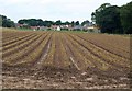
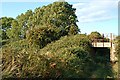
Field, Boarhills
A similar view to Image, taken from further east, looking along lines of stubble from the A917.
Image: © Derek Harper
Taken: 15 Aug 2008
0.19 miles
7
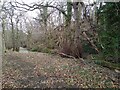
Banks of Kenly river
After several days with downpours, the river looks like a raging monster. This path ends a bit further down the stream.
Image: © Aleks Scholz
Taken: 20 Feb 2022
0.25 miles