IMAGES TAKEN NEAR TO
KY16 6BJ
Introduction
This page details the photographs taken nearby to KY16 6BJ by members of the Geograph project.
The Geograph project started in 2005 with the aim of publishing, organising and preserving representative images for every square kilometre of Great Britain, Ireland and the Isle of Man.

There are currently over 7.5m images from over14,400 individuals and you can help contribute to the project by visiting https://www.geograph.org.uk
Image Map
Images are licensed for reuse under creativecommons.org/licenses/by-sa/2.0
Notes
- Clicking on the map will re-center to the selected point.
- The higher the marker number, the further away the image location is from the centre of the postcode.
Image Listing (31 Images Found)
Images are licensed for reuse under creativecommons.org/licenses/by-sa/2.0
Image
Details
Distance
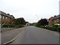
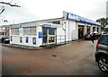
2
Lamond Drive approaching the junction with Largo Road
Image: © Mark Anderson
Taken: 22 Aug 2021
0.03 miles
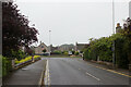
3
Lamond Drive, St Andrews
Junction with the A915.
Image: © JThomas
Taken: 21 Jul 2021
0.03 miles
4
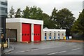
St Andrews Fire Station
On the A915, Largo Road.
Image: © Richard Sutcliffe
Taken: 24 Sep 2019
0.05 miles
6
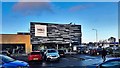
M & S Foodhall, Largo Road, St Andrews
Image: © Ian Hawfinch
Taken: 20 Feb 2020
0.07 miles

9
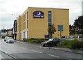
Premier Inn, St Andrews
On the A915, Largo Road.
Image: © Richard Sutcliffe
Taken: 24 Sep 2019
0.11 miles
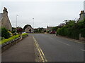
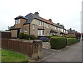
10
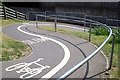
S bends
S bends on the Canongate end of Viaduct Walk and cycleway which links the old town with the newer housing to the south of the town. This was where the old railway line crossed the Canongate.
Image: © Jim Bain
Taken: 5 May 2007
0.13 miles