IMAGES TAKEN NEAR TO
Earlshall Road, ST. ANDREWS, KY16 0EN
Introduction
This page details the photographs taken nearby to Earlshall Road, KY16 0EN by members of the Geograph project.
The Geograph project started in 2005 with the aim of publishing, organising and preserving representative images for every square kilometre of Great Britain, Ireland and the Isle of Man.

There are currently over 7.5m images from over14,400 individuals and you can help contribute to the project by visiting https://www.geograph.org.uk
Image Map
Images are licensed for reuse under creativecommons.org/licenses/by-sa/2.0
Notes
- Clicking on the map will re-center to the selected point.
- The higher the marker number, the further away the image location is from the centre of the postcode.
Image Listing (112 Images Found)
Images are licensed for reuse under creativecommons.org/licenses/by-sa/2.0
Image
Details
Distance
1
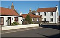
School Hill, Leuchars
Looking east along School Hill and junction with Henderson Terr.
Image: © Jim Bain
Taken: 2 Mar 2007
0.01 miles
2
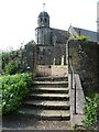
Steps to St. Athernase's
The north-east entrance gate to the kirkyard.
Image: © kim traynor
Taken: 11 Jun 2013
0.02 miles
3
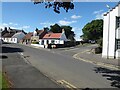
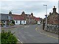
Junction of School Hill and Pitlethie Road
Road junction by St Athernase's Church in Leuchars.
Image: © Oliver Dixon
Taken: 20 Aug 2022
0.02 miles
4
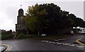
Junction of Schoolhill with Pitlethie Road
In Leuchars; with St Athenase's Church ahead.
Image: © Stanley Howe
Taken: 6 Oct 2015
0.02 miles
6
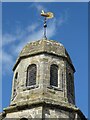
Belfry, St Athernase Church
The Belfry is a relatively recent (18th century) addition to the 12th Century church.
Image: © Oliver Dixon
Taken: 20 Aug 2022
0.03 miles
7
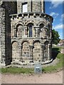
The Apse, St Athernase Church
The Romanesque Apse incorporating Norman arches dates from the 12th Century. Category A listed.
Image: © Oliver Dixon
Taken: 20 Aug 2022
0.03 miles
8
National Cycle Route 1, Leuchars
Looking north east on Pitlethie Road.
Image: © JThomas
Taken: 19 Jul 2021
0.03 miles
9
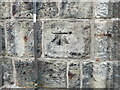
Ordnance Survey Cut Mark with Bolt
This can be found on the wall of St Athernase Church, Leuchars. The bolt has bolted leaving only a large hole. The benchmark has a recorded height of 19.486 metres above sea level.
For more detail see : https://www.bench-marks.org.uk/bm32021
Image: © Peter Wood
Taken: 9 May 2021
0.03 miles
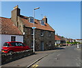
10
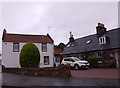
Housing on the corner of Schoolhill/Pitlethie Road
Leuchars.
Image: © Stanley Howe
Taken: 6 Oct 2015
0.03 miles