IMAGES TAKEN NEAR TO
Lucklaw Hill, ST. ANDREWS, KY16 0BL
Introduction
This page details the photographs taken nearby to Lucklaw Hill, KY16 0BL by members of the Geograph project.
The Geograph project started in 2005 with the aim of publishing, organising and preserving representative images for every square kilometre of Great Britain, Ireland and the Isle of Man.

There are currently over 7.5m images from over14,400 individuals and you can help contribute to the project by visiting https://www.geograph.org.uk
Image Map
Images are licensed for reuse under creativecommons.org/licenses/by-sa/2.0
Notes
- Clicking on the map will re-center to the selected point.
- The higher the marker number, the further away the image location is from the centre of the postcode.
Image Listing (18 Images Found)
Images are licensed for reuse under creativecommons.org/licenses/by-sa/2.0
Image
Details
Distance
1
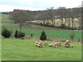
Modern stone circle
A piece of landscape gardening on the lawn beside Lucklaw Steading development.
Image: © James Allan
Taken: 19 Apr 2010
0.02 miles
2
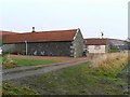
Farm Cottages
Cottages at Lucklaw Farm, with the face of Lucklaw quarry just visible to their right.
Image: © James Allan
Taken: 15 Dec 2008
0.03 miles
4

Leafy tunnel
A tunnel of trees with a path running through it, between Willie's Wood and Lucklaw.
Image: © Scott Cormie
Taken: 23 Apr 2017
0.05 miles
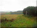
6
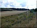
View Towards Lucklaw
A view down the edge of the minor road towards Lucklaw showing a field of cereals awaiting harvest and woodland.
Image: © Rude Health
Taken: 7 Aug 2014
0.09 miles
7
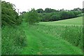
Green Road
On the northern edge of the Cuplahills reserve.
Image: © Jim Bain
Taken: 20 Jun 2007
0.10 miles
8
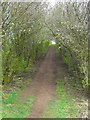
Track in a tunnel
Walking path through overarching trees.
Image: © James Allan
Taken: 19 Apr 2010
0.14 miles
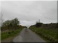
9
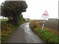
Road over Lucklaw Hill
Warning sign as to poor condition of the road but it was not too bad today.
Image: © Richard Webb
Taken: 4 Oct 2013
0.15 miles
10
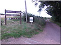
Track to Cuplahills Community Woodland
From the minor road by Ardlogie.
Image: © Stanley Howe
Taken: 12 Aug 2015
0.15 miles