IMAGES TAKEN NEAR TO
Collessie, CUPAR, KY15 7RQ
Introduction
This page details the photographs taken nearby to KY15 7RQ by members of the Geograph project.
The Geograph project started in 2005 with the aim of publishing, organising and preserving representative images for every square kilometre of Great Britain, Ireland and the Isle of Man.

There are currently over 7.5m images from over14,400 individuals and you can help contribute to the project by visiting https://www.geograph.org.uk
Image Map
Images are licensed for reuse under creativecommons.org/licenses/by-sa/2.0
Notes
- Clicking on the map will re-center to the selected point.
- The higher the marker number, the further away the image location is from the centre of the postcode.
Image Listing (29 Images Found)
Images are licensed for reuse under creativecommons.org/licenses/by-sa/2.0
Image
Details
Distance
2
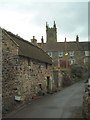
Houses and church, Collessie
Viewed from beneath the railway bridge.
Image: © Dave Fergusson
Taken: 31 Aug 2010
0.02 miles
3
Benchmark on Collessie Parish Church
Ordnance Survey benchmark, described on database at https://www.bench-marks.org.uk/bm105835. See also https://www.geograph.org.uk/photo/6096762.
Image: © Becky Williamson
Taken: 24 Feb 2019
0.02 miles
4
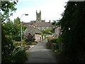
Collessie village and church
Taken from close to the railway bridge
Image: © James Allan
Taken: 13 Feb 2006
0.02 miles
5
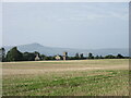
Tower of Collessie Church
A distant view from the north-east of the tower of Collessie Parish Church, with East Lomond beyond.
Image: © Scott Cormie
Taken: 5 Sep 2021
0.02 miles
7
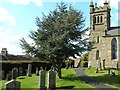
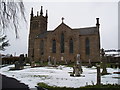
Collessie Kirk
Looking from across the graveyard.
Image: © James Allan
Taken: 14 Apr 2014
0.02 miles
8
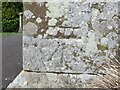
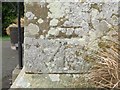
Ordnance Survey Cut Mark
The mark can be found on the wall of Collessie Parish Church.
This benchmark has a recorded height of 66.1111 metres above sea level.
For more detail see : https://www.bench-marks.org.uk/bm105835
Image: © Peter Wood
Taken: 11 May 2021
0.02 miles
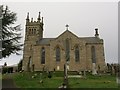
9
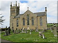
Collessie Parish Church and part of its Burial Ground
Viewed from the southeast.
Image: © Peter Wood
Taken: 11 May 2021
0.03 miles
10
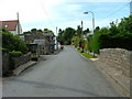
Collessie Main street
The bridge in the foreground crosses the Den Burn.
Image: © Dave Fergusson
Taken: 31 Aug 2010
0.04 miles