IMAGES TAKEN NEAR TO
North Street, CUPAR, KY15 7QH
Introduction
This page details the photographs taken nearby to North Street, KY15 7QH by members of the Geograph project.
The Geograph project started in 2005 with the aim of publishing, organising and preserving representative images for every square kilometre of Great Britain, Ireland and the Isle of Man.

There are currently over 7.5m images from over14,400 individuals and you can help contribute to the project by visiting https://www.geograph.org.uk
Image Map
Images are licensed for reuse under creativecommons.org/licenses/by-sa/2.0
Notes
- Clicking on the map will re-center to the selected point.
- The higher the marker number, the further away the image location is from the centre of the postcode.
Image Listing (16 Images Found)
Images are licensed for reuse under creativecommons.org/licenses/by-sa/2.0
Image
Details
Distance
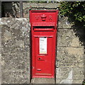
1
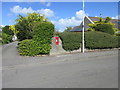
VR Wallbox at Kettle
VR embossed wallbox at Rumdewan between Kettlebridge and Kingskettle.
Image: © Scott Cormie
Taken: 11 May 2019
0.06 miles
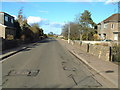
2
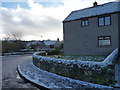
Kettlebridge corner
Street corner in the village of Kettlebridge after a light fall of snow.
Image: © James Allan
Taken: 3 Dec 2012
0.07 miles
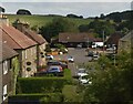
3
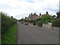
Kettlebridge
Rumdewan Terrace, Kettlebridge
Image: © Richard Webb
Taken: 12 Aug 2009
0.08 miles
4
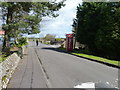
Telephone box
In North Street, Kettlebridge.
Image: © James Allan
Taken: 2 May 2016
0.08 miles
5
Victorian Wallbox at Kettle
VR embossed wallbox at Rumdewan Terrace in Kettle.
Image: © Scott Cormie
Taken: 11 May 2019
0.10 miles
6
Kettlebridge
Main street (Rumdewan) in the village of Kettlebridge
Image: © James Allan
Taken: 17 Apr 2006
0.11 miles
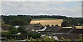
9
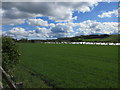
Green field at Kettle
Large field alongside Rumdewan between Kettlebridge and Kingskettle.
Image: © Scott Cormie
Taken: 11 May 2019
0.14 miles
