IMAGES TAKEN NEAR TO
Ramornie Place, CUPAR, KY15 7PT
Introduction
This page details the photographs taken nearby to Ramornie Place, KY15 7PT by members of the Geograph project.
The Geograph project started in 2005 with the aim of publishing, organising and preserving representative images for every square kilometre of Great Britain, Ireland and the Isle of Man.

There are currently over 7.5m images from over14,400 individuals and you can help contribute to the project by visiting https://www.geograph.org.uk
Image Map
Images are licensed for reuse under creativecommons.org/licenses/by-sa/2.0
Notes
- Clicking on the map will re-center to the selected point.
- The higher the marker number, the further away the image location is from the centre of the postcode.
Image Listing (27 Images Found)
Images are licensed for reuse under creativecommons.org/licenses/by-sa/2.0
Image
Details
Distance
3
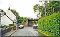
Station Inn
There is no station in Kingskettle nowadays, but the Station Inn is still functioning. The shadow in the foreground is of the railway bridge.
Image: © James Allan
Taken: 3 May 2010
0.07 miles
4
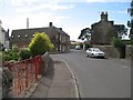
Parliament Square
A narrow village lane with rather a grandiose name.
Image: © James Allan
Taken: 3 May 2010
0.08 miles
5
Site of former Kingskettle station
View eastward, the station (closed 4/9/67) having been to the right of the bridge: ex-NBR main line Edinburgh etc. - Ladybank - Dundee - Montrose - Kinnaber Junction - Aberdeen.
Image: © Ben Brooksbank
Taken: 1 Jul 2002
0.08 miles
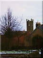
6

Kingskettle church clad in scaffold
Looking from Kettlebridge across Rumdewan towards Kingskettle.
Image: © James Allan
Taken: 3 Dec 2012
0.09 miles
8
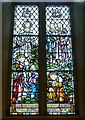
Kettle Parish War Memorial window
War Memorial window in Kettle Parish Kirk. Its detail can be better appreciated by downloading a larger image via the 'More sizes' button.
Image: © kim traynor
Taken: 30 Aug 2013
0.13 miles
9
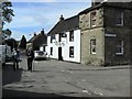
Kingskettle
An attractive village in Fife locally known as Kettle which developed in an area which once belonged to the Crown and where an unrecorded battle or Cathel took place, this is how the name Kingskettle came about. The village developed in the 19th century with the opening of the turnpike road and with the development of mining and weaving.
Image: © Kevin Rae
Taken: 20 Feb 2006
0.13 miles
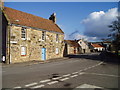
10
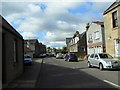
South Street, Kingskettle
Viewed from near the church.
Image: © James Allan
Taken: 3 May 2010
0.13 miles