IMAGES TAKEN NEAR TO
Shorehead, CUPAR, KY15 7PH
Introduction
This page details the photographs taken nearby to Shorehead, KY15 7PH by members of the Geograph project.
The Geograph project started in 2005 with the aim of publishing, organising and preserving representative images for every square kilometre of Great Britain, Ireland and the Isle of Man.

There are currently over 7.5m images from over14,400 individuals and you can help contribute to the project by visiting https://www.geograph.org.uk
Image Map
Images are licensed for reuse under creativecommons.org/licenses/by-sa/2.0
Notes
- Clicking on the map will re-center to the selected point.
- The higher the marker number, the further away the image location is from the centre of the postcode.
Image Listing (18 Images Found)
Images are licensed for reuse under creativecommons.org/licenses/by-sa/2.0
Image
Details
Distance
1
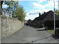
The Shorelands
Kingskettle is a long way from the sea or any other body of water today, but the name of this road is The Shorelands. Perhaps there once was a loch near here?
Image: © James Allan
Taken: 3 May 2010
0.01 miles
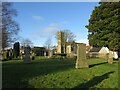
3
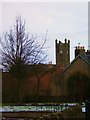
Church at Kingskettle
Church of Scotland Parish Church
Image: © Barbara Carr
Taken: 13 Feb 2009
0.08 miles
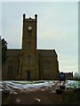
5
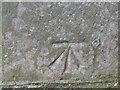
1GL Bolt Benchmark on Kingskettle Parish Church
Ordnance Survey 1GL bolt benchmark, described on database at https://www.bench-marks.org.uk/bm142094. See also Image
Image: © Becky Williamson
Taken: 27 Feb 2021
0.08 miles
6
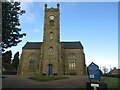
Kingskettle Parish Church
There is a 1GL Bolt benchmark on this building. See Image
Image: © Becky Williamson
Taken: 27 Feb 2021
0.08 miles
7
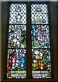
Kettle Parish War Memorial window
War Memorial window in Kettle Parish Kirk. Its detail can be better appreciated by downloading a larger image via the 'More sizes' button.
Image: © kim traynor
Taken: 30 Aug 2013
0.09 miles
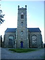
8
Howe of Fife Parish Church, Kingskettle
View west along main road towards the church which stands on the western edge of this grid square, The church was built in 1853 and is a very fine and attractive building which can be seen from afar and which lies within a very attractive small village.
Image: © Kevin Rae
Taken: 20 Feb 2006
0.10 miles
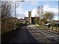
10
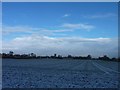
Kingskettle church clad in scaffold
Looking from Kettlebridge across Rumdewan towards Kingskettle.
Image: © James Allan
Taken: 3 Dec 2012
0.13 miles