IMAGES TAKEN NEAR TO
Golf Street, CUPAR, KY15 7NT
Introduction
This page details the photographs taken nearby to Golf Street, KY15 7NT by members of the Geograph project.
The Geograph project started in 2005 with the aim of publishing, organising and preserving representative images for every square kilometre of Great Britain, Ireland and the Isle of Man.

There are currently over 7.5m images from over14,400 individuals and you can help contribute to the project by visiting https://www.geograph.org.uk
Image Map
Images are licensed for reuse under creativecommons.org/licenses/by-sa/2.0
Notes
- Clicking on the map will re-center to the selected point.
- The higher the marker number, the further away the image location is from the centre of the postcode.
Image Listing (14 Images Found)
Images are licensed for reuse under creativecommons.org/licenses/by-sa/2.0
Image
Details
Distance
1
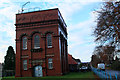
Ladybank Water Works
Lovely red brick building just over one hundred year old, engraving above the door says it is Ladybank Water Works,can't be sure if it is still in use.
Image: © edward mcmaihin
Taken: 27 Nov 2013
0.11 miles
2
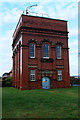
Ladybank Water Works
The water works viewed from Golf Street.
Image: © edward mcmaihin
Taken: 27 Nov 2013
0.11 miles
3
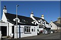
The Golf Inn, Ladybank
It looked attractive but I didn't have time to stop...
Image: © Bill Harrison
Taken: 20 Apr 2023
0.16 miles
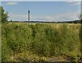
6
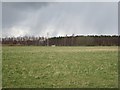
Grass field, Ladybank
Sandy ground with many woods and gravel pits. The mast is beside the railway between Edinburgh and Dundee.
Image: © Richard Webb
Taken: 26 Apr 2013
0.20 miles
7
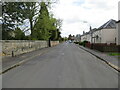
Church Street, Ladybank
Looking south-eastward.
Image: © Peter Wood
Taken: 11 May 2021
0.21 miles
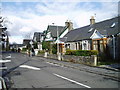
8
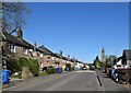
Council houses, Church Street, Ladybank
Image: © Bill Harrison
Taken: 20 Apr 2023
0.21 miles
9
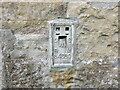
Ordnance Survey Flush Bracket S4589
The bracket can be found on the wall of Ladybank Parish Church.
This benchmark has a recorded height of 46.083 metres above sea level.
For more detail see : https://www.bench-marks.org.uk/bm10706
Image: © Peter Wood
Taken: 11 May 2021
0.21 miles
10
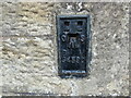
Ordnance Survey Flush Bracket S4590
The bracket can be found on the wall of Ladybank Primary School.
This benchmark has a recorded height of 41.5104 metres above sea level.
For more detail see : https://www.bench-marks.org.uk/bm19365
Image: © Peter Wood
Taken: 11 May 2021
0.22 miles