IMAGES TAKEN NEAR TO
East End, CUPAR, KY15 7ET
Introduction
This page details the photographs taken nearby to East End, KY15 7ET by members of the Geograph project.
The Geograph project started in 2005 with the aim of publishing, organising and preserving representative images for every square kilometre of Great Britain, Ireland and the Isle of Man.

There are currently over 7.5m images from over14,400 individuals and you can help contribute to the project by visiting https://www.geograph.org.uk
Image Map
Images are licensed for reuse under creativecommons.org/licenses/by-sa/2.0
Notes
- Clicking on the map will re-center to the selected point.
- The higher the marker number, the further away the image location is from the centre of the postcode.
Image Listing (29 Images Found)
Images are licensed for reuse under creativecommons.org/licenses/by-sa/2.0
Image
Details
Distance
1
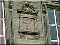
Plaque on Lumsden Memorial Hall
The Hall is built on the site of the first church in Freuchie. The Hall was left in Trust by Helen Lumsden in 1883 in memory of her husband Thomas Lumsden, Linen Manufacturer, for the benefit of the inhabitants of Freuchie. The building houses Freuchie Public Library and is also used as the community hall. See Image
Image: © Dave Fergusson
Taken: 1 Sep 2010
0.06 miles
2
Lumsden Memorial Hall, Freuchie
The Hall is built on the site of the first church in Freuchie. The Hall was left in Trust by Helen Lumsden in 1883 in memory of her husband Thomas Lumsden, Linen Manufacturer, for the benefit of the inhabitants of Freuchie. The building houses Freuchie Public Library and is also used as the community hall.
Image: © Dave Fergusson
Taken: 1 Sep 2010
0.06 miles
3
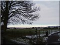
Towards Kingskettle
Looking NE from the junction of the public footpath and a private drive, from a point just east of the centre of Freuchie.
Image: © Barbara Carr
Taken: 13 Feb 2009
0.11 miles
4
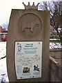
Local Information Board
Local information attractively presented in a modern setting.
Image: © Barbara Carr
Taken: 13 Feb 2009
0.12 miles
5
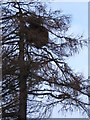
Larch tree with strange growth
Not a massive nest in this tree, but an abnormal growth probably caused by insect or fungal attack
Image: © Barbara Carr
Taken: 13 Feb 2009
0.12 miles
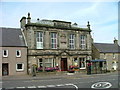
6
Lomond Hills Hotel, Freuchie
On the junction of High Street and Lomond Road.
Image: © Dave Fergusson
Taken: 1 Sep 2010
0.12 miles
7
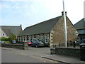
Freuchie Primary School
On Lomond Road.
Image: © Dave Fergusson
Taken: 1 Sep 2010
0.14 miles
8
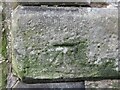
Benchmark on house, Eden Valley Row, Freuchie
Ordnance Survey benchmark, described on database at https://www.bench-marks.org.uk/bm142093.
Image: © Becky Williamson
Taken: 27 Feb 2021
0.16 miles
9
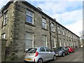
Eden Valley Row, Freuchie
There is an Ordnance Survey benchmark on the house on the left.
Image: © Becky Williamson
Taken: 27 Feb 2021
0.16 miles
10
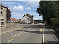
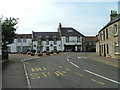
Freuchie
High Street at the junction with Queen Street.
Image: © Richard Webb
Taken: 31 Jul 2009
0.16 miles