IMAGES TAKEN NEAR TO
Falkland, CUPAR, KY15 7BD
Introduction
This page details the photographs taken nearby to KY15 7BD by members of the Geograph project.
The Geograph project started in 2005 with the aim of publishing, organising and preserving representative images for every square kilometre of Great Britain, Ireland and the Isle of Man.

There are currently over 7.5m images from over14,400 individuals and you can help contribute to the project by visiting https://www.geograph.org.uk
Image Map
Images are licensed for reuse under creativecommons.org/licenses/by-sa/2.0
Notes
- Clicking on the map will re-center to the selected point.
- The higher the marker number, the further away the image location is from the centre of the postcode.
Image Listing (117 Images Found)
Images are licensed for reuse under creativecommons.org/licenses/by-sa/2.0
Image
Details
Distance
1
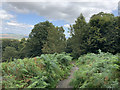
Water treatment facility, Lomond Hills
A few yards up the path to East Lomond from this image Image] is this water treatment plant belonging to Scottish Water.
See Lomond Hills Regional Park article http://www.geograph.org.uk/article/Lomond-Hills-Regional-Park
Image: © Bill Kasman
Taken: 21 May 2017
0.04 miles
2
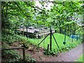
Water Works above Falkland
This appears to be an underground reservoir or some other infrastructure concerned with water supply.
Image: © Robert Struthers
Taken: 7 Nov 2020
0.05 miles
3
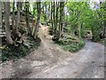
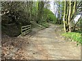
Path past Lomondside Cottage, Falkland
The path past the cottage Image] continues (right) towards the house at Allan Park. Heading uphill to the left is a path which ascends Falkland Hill (East Lomond) See also this image Image]
See Falkland article http://www.geograph.org.uk/article/Falkland-An-historic-village
Image: © Bill Kasman
Taken: 23 Apr 2017
0.06 miles
4
Path past Lomondside Cottage, Falkland
A few metres further along the track to the house at Allan Park from this image Image] can be found another path leading to the summit of East Lomond.
See Falkland article http://www.geograph.org.uk/article/Falkland-An-historic-village
See Lomond Hills Regional Park article http://www.geograph.org.uk/article/Lomond-Hills-Regional-Park
Image: © Bill Kasman
Taken: 29 Apr 2017
0.06 miles
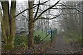
5
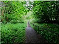
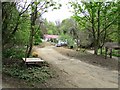
Path and woodland, Allan Park
The path from East Lomond descends here towards Falkland.
Image: © John Allan
Taken: 26 Aug 2019
0.07 miles
6
Path past Lomondside Cottage, Falkland
The path from the top of East Loan Image] continues past Lomondside Cottage.
See Falkland article http://www.geograph.org.uk/article/Falkland-An-historic-village
Image: © Bill Kasman
Taken: 23 Apr 2017
0.07 miles
7
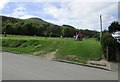
Play area, Falkland
This children's play area is near the top of East Loan between Back Dykes Terrace and the House at Allan Park (just visible left of centre). Falkland Hill (East Lomond) is prominent.
See Falkland article http://www.geograph.org.uk/article/Falkland-An-historic-village
Image: © Bill Kasman
Taken: 23 Apr 2017
0.08 miles
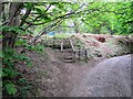
8
Steps to East Lomond, Lomond Hills
From the same position as this image Image] we see the first of several sets of steps leading through the woods.
See Lomond Hills Regional Park article http://www.geograph.org.uk/article/Lomond-Hills-Regional-Park
Image: © Bill Kasman
Taken: 21 May 2017
0.08 miles
9
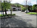
Covenanter Court, Falkland
Seen from Cameron Drive Image]
See Falkland article http://www.geograph.org.uk/article/Falkland-An-historic-village
Image: © Bill Kasman
Taken: 23 Apr 2017
0.09 miles
10
Lomondside Cottage, Falkland
A short distance along the path from the top of East Loan Image] is Lomondside Cottage. There is a path to the right of the cottage which leads to the house at Allan Park and to a path which climbs to the summit of East Lomond Image]
See Falkland article http://www.geograph.org.uk/article/Falkland-An-historic-village
Image: © Bill Kasman
Taken: 29 Apr 2017
0.09 miles