IMAGES TAKEN NEAR TO
Crawford Park, CUPAR, KY15 5SW
Introduction
This page details the photographs taken nearby to Crawford Park, KY15 5SW by members of the Geograph project.
The Geograph project started in 2005 with the aim of publishing, organising and preserving representative images for every square kilometre of Great Britain, Ireland and the Isle of Man.

There are currently over 7.5m images from over14,400 individuals and you can help contribute to the project by visiting https://www.geograph.org.uk
Image Map
Images are licensed for reuse under creativecommons.org/licenses/by-sa/2.0
Notes
- Clicking on the map will re-center to the selected point.
- The higher the marker number, the further away the image location is from the centre of the postcode.
Image Listing (22 Images Found)
Images are licensed for reuse under creativecommons.org/licenses/by-sa/2.0
Image
Details
Distance
1
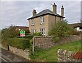
Station Road, Springfield, Fife
Former Police Station.
Image: © Alisdair Mclean
Taken: 21 Jun 2020
0.04 miles
2
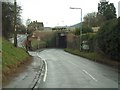
Springfield Station
Railway bridge at Springfield station
Image: © James Allan
Taken: 13 Feb 2006
0.08 miles
3
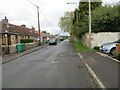
Station Road at Crawley Cottages, Springfield
Looking eastward.
Image: © Peter Wood
Taken: 12 May 2021
0.09 miles
4
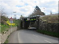
Railway bridge at Springfield
Railway bridge near Springfield Station.
Image: © Scott Cormie
Taken: 13 Apr 2019
0.10 miles
6
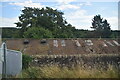
After the harvest
Field of stubble north of Springfield village.
Image: © James Allan
Taken: 9 Sep 2013
0.11 miles
7
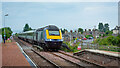
1A91 Edinburgh to Aberdeen service at Springfield
Image: © Peter Moore
Taken: 28 Jul 2022
0.12 miles
8
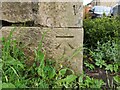
Ordnance Survey Cut Mark
The mark can be found on the roadside boundary wall of Crawley House, Springfield.
The benchmark has a recorded height of 40.1867 metres above sea level.
For more detail see : https://www.bench-marks.org.uk/bm114172
Image: © Peter Wood
Taken: 12 May 2021
0.12 miles
9
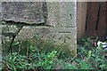
Benchmark on wall, Crawley House, Springfield
Ordnance Survey benchmark, described on database at https://www.bench-marks.org.uk/bm114172. See Image] for picture of wall and gateway.
Image: © Becky Williamson
Taken: 17 Dec 2019
0.12 miles
10
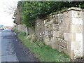
Boundary Wall,Crawley House, Springfield
An Ordnance Survey benchmark can be seen at the bottom right of the photo. For close up photo, see and for database entry, see https://www.geograph.org.uk/photo/6347903. See also https://www.geograph.org.uk/photo/6347905.
Image: © Becky Williamson
Taken: 22 Feb 2022
0.12 miles