IMAGES TAKEN NEAR TO
CUPAR, KY15 5PQ
Introduction
This page details the photographs taken nearby to KY15 5PQ by members of the Geograph project.
The Geograph project started in 2005 with the aim of publishing, organising and preserving representative images for every square kilometre of Great Britain, Ireland and the Isle of Man.

There are currently over 7.5m images from over14,400 individuals and you can help contribute to the project by visiting https://www.geograph.org.uk
Image Map
Images are licensed for reuse under creativecommons.org/licenses/by-sa/2.0
Notes
- Clicking on the map will re-center to the selected point.
- The higher the marker number, the further away the image location is from the centre of the postcode.
Image Listing (10 Images Found)
Images are licensed for reuse under creativecommons.org/licenses/by-sa/2.0
Image
Details
Distance
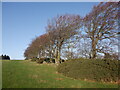
1

Minor road at Findas Knowe
Looking south-westward.
Image: © Peter Wood
Taken: 13 May 2021
0.03 miles
2
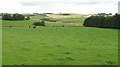
Grazing cattle, Findas
An area of grassland amongst the predominantly arable land hereabouts.
Image: © Richard Webb
Taken: 12 Aug 2009
0.09 miles
5
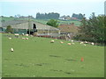
Ring Farm
Well-fed sheep grazing in front of rather dilapidated farm buildings
Image: © James Allan
Taken: 14 May 2006
0.16 miles
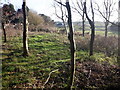
6
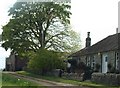
Cottages near Chance Inn
Farm cottages to the west of the village of Chance Inn
Image: © James Allan
Taken: 14 May 2006
0.17 miles
7
Waltonhill
Several new houses as part of steading conversion.
Image: © Richard Webb
Taken: 12 Aug 2009
0.17 miles
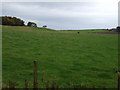
8
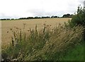
Arable land, Findas
Arable land on a south facing gentle slope.
Image: © Richard Webb
Taken: 12 Aug 2009
0.21 miles
9
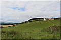
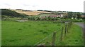
View over Fife countryside
The buildings of Walton Hill Farm are prominent.
Image: © Bill Kasman
Taken: 30 Aug 2020
0.22 miles