IMAGES TAKEN NEAR TO
CUPAR, KY15 5NY
Introduction
This page details the photographs taken nearby to KY15 5NY by members of the Geograph project.
The Geograph project started in 2005 with the aim of publishing, organising and preserving representative images for every square kilometre of Great Britain, Ireland and the Isle of Man.

There are currently over 7.5m images from over14,400 individuals and you can help contribute to the project by visiting https://www.geograph.org.uk
Image Map
Images are licensed for reuse under creativecommons.org/licenses/by-sa/2.0
Notes
- Clicking on the map will re-center to the selected point.
- The higher the marker number, the further away the image location is from the centre of the postcode.
Image Listing (6 Images Found)
Images are licensed for reuse under creativecommons.org/licenses/by-sa/2.0
Image
Details
Distance
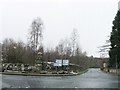
2

South East of Springfield
The cross-roads where the road from Springfield crosses the A92 trunk road, seen from the Scotstarvit road
Image: © James Allan
Taken: 13 Feb 2006
0.04 miles
3
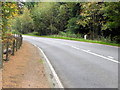
A914, Clushford Toll
Beside the A914, is a 1824 milestone.
Milestones are the original roadside heritage features with many dating back hundreds of years and these historic items are under threat from highway developments.
Image: © Maigheach-gheal
Taken: 13 Oct 2010
0.10 miles
4
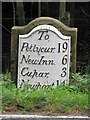
Milestone, Clushford Toll
Milestones did not come into general use until the Turnpike Act of 1766 made them compulsory on turnpike roads, these roads were built by private enterprise under licence from the Government and maintained by tolls on those who used them. Before this Act milestones were put up occasionally, often as charitable acts and commemorations. Many Turnpike Act stones still exist. They are usually 2-3 ft high, with the initial letter or abbreviation of the nearest market town show on two faces, and the distance from it.
For a wider view of the stone Image
Image: © Maigheach-gheal
Taken: 13 Oct 2010
0.12 miles
5
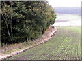
Arable fields near Springfield
The cereal crop is coming on well. The woodland is part of Bogle Wood.
Image: © Maigheach-gheal
Taken: 13 Oct 2010
0.20 miles
6
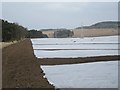
Crops under netting
A slow start to the growing season with a long Winter and cold Spring.
Image: © Richard Webb
Taken: 11 Apr 2013
0.22 miles