IMAGES TAKEN NEAR TO
Wemyss Place, South Road, CUPAR, KY15 5JQ
Introduction
This page details the photographs taken nearby to Wemyss Place, South Road, KY15 5JQ by members of the Geograph project.
The Geograph project started in 2005 with the aim of publishing, organising and preserving representative images for every square kilometre of Great Britain, Ireland and the Isle of Man.

There are currently over 7.5m images from over14,400 individuals and you can help contribute to the project by visiting https://www.geograph.org.uk
Image Map
Images are licensed for reuse under creativecommons.org/licenses/by-sa/2.0
Notes
- Clicking on the map will re-center to the selected point.
- The higher the marker number, the further away the image location is from the centre of the postcode.
Image Listing (36 Images Found)
Images are licensed for reuse under creativecommons.org/licenses/by-sa/2.0
Image
Details
Distance
1
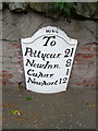
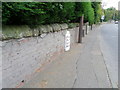
Milestone, Cupar
Milestones did not come into general use until the Turnpike Act of 1766 made them compulsory on turnpike roads, these roads were built by private enterprise under licence from the Government and maintained by tolls on those who used them. Before this Act milestones were put up occasionally, often as charitable acts and commemorations. Many Turnpike Act stones still exist. They are usually 2-3 ft high, with the initial letter or abbreviation of the nearest market town show on two faces, and the distance from it.
For a wider view of the stone Image
Image: © Maigheach-gheal
Taken: 13 Oct 2010
0.06 miles
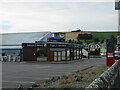
2
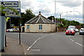
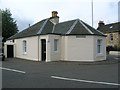
South Toll, Cupar
The South toll house controlled barriers on the road to each side of it. The Ceres road to the left and the main road south to the right.
Image: © Jim Bain
Taken: 15 Jun 2008
0.07 miles
3
Cow Bridge over the River Eden
To get the cows from the fields into Cupar?
Image: © Russel Wills
Taken: 11 Apr 2013
0.07 miles
4
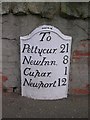
Old Milepost by the A92, South Road, Cupar
Cast iron plate by the A92, in parish of Cupar (Fife District), South Road, Cupar, Skelpie Park in wall, near LP 25.
Inscription reads:- : 1824 / To / Pettycur, 21 / NewInn, 8 / Cupar, 1 / Newport, 12 :
Surveyed
Milestone Society National ID: FF_NPCP12.
Image: © Milestone Society
Taken: Unknown
0.07 miles
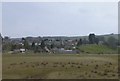
5
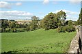
Grazing by the Eden
Looking towards the oldest area of Cupar in the distance.
Image: © Jim Bain
Taken: 2 Sep 2007
0.09 miles
6
Van on roof
Old delivery van on the roof of Fisher & Donaldson's Tearoom in Cupar.
Image: © Scott Cormie
Taken: 26 Sep 2021
0.09 miles
7
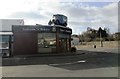
Fisher and Donaldson cafe, Cupar
This tearoom and cafe in the Fife town of Cupar has an unusual advertising display - a Model-T Ford delivery van on the roof!
Image: © Bill Kasman
Taken: 25 Feb 2018
0.11 miles
9
A914, Cupar
Beside the A914, set into the roadside wall is a milestone dating from 1824.
Image: © Maigheach-gheal
Taken: 13 Oct 2010
0.12 miles
10
Former Tollhouse by Ceres Road, Cupar
Cupar South Toll House by the A914, in parish of Cupar (Fife District), The Toll House (Primrose Cottage, No. 1), Ceres Road.
HES Scotland Category 'C' listed.
Reference: LB24297 http://portal.historicenvironment.scot/designation/LB24297
Surveyed
Milestone Society National ID: FF.CUP02
Image: © Milestone Society
Taken: Unknown
0.13 miles