IMAGES TAKEN NEAR TO
Dairsie, CUPAR, KY15 4SW
Introduction
This page details the photographs taken nearby to KY15 4SW by members of the Geograph project.
The Geograph project started in 2005 with the aim of publishing, organising and preserving representative images for every square kilometre of Great Britain, Ireland and the Isle of Man.

There are currently over 7.5m images from over14,400 individuals and you can help contribute to the project by visiting https://www.geograph.org.uk
Image Map
Images are licensed for reuse under creativecommons.org/licenses/by-sa/2.0
Notes
- Clicking on the map will re-center to the selected point.
- The higher the marker number, the further away the image location is from the centre of the postcode.
Image Listing (13 Images Found)
Images are licensed for reuse under creativecommons.org/licenses/by-sa/2.0
Image
Details
Distance
1
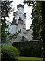
Pittormie Castle
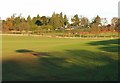
Formerly the home of the first Duke of Fife, the original castle was given to Ludovic of Lennox by King James VI in 1596. The derelict building was restored in 2005 and is now the centrepiece of the Eden Club which is claimed to be the most luxurious private club in Scotland, complete with its own swimming pool, gym, spa, tennis courts and other on-site facilities. Members also have access to their own luxurious private residences. Membership of the Eden Clib is strictly by invitation and is drawn from individuals that belong to other fine private clubs around the world. All applicants are screened and an interview with the Chairman is mandatory. The Club reserves the right to refuse membership to any unsuitable applicant and no reason will be given. And if you have to ask what membership costs, you probably can't afford it anyway.
Image: © James Allan
Taken: 25 Aug 2014
0.04 miles
2
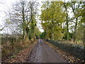
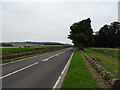
Autumn leaves
On a side road near Pittormie Castle.
Image: © James Allan
Taken: 14 Nov 2016
0.05 miles
5
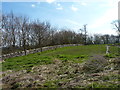
Stone wall and shelter belt
Near Pittormie Castle.
Image: © James Allan
Taken: 6 Apr 2015
0.13 miles
6
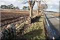
Gateposts at Pittormie, near Dairsie
There is an Ordnance Survey benchmark on the right-hand gatepost. See Image
Image: © Becky Williamson
Taken: 29 Feb 2020
0.13 miles
7
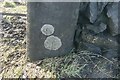
Benchmark on gatepost at Pittormie
Ordnance Survey benchmark, described on database at https://www.bench-marks.org.uk/bm116631. See also Image
Image: © Becky Williamson
Taken: 29 Feb 2020
0.13 miles
8
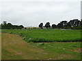
Pittormie
Pittormie house and grounds beyond the field. Put up for sale in Sep 05 for offers over 2.5 million. It's one of the major houses around St Andrews.
Image: © Jim Bain
Taken: 6 Dec 2005
0.14 miles
9
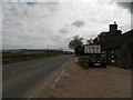
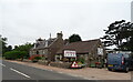
Farm shop at side of A914 at Pittormie
Image: © Douglas Nelson
Taken: 29 Apr 2017
0.17 miles