IMAGES TAKEN NEAR TO
Dairsie, CUPAR, KY15 4SQ
Introduction
This page details the photographs taken nearby to KY15 4SQ by members of the Geograph project.
The Geograph project started in 2005 with the aim of publishing, organising and preserving representative images for every square kilometre of Great Britain, Ireland and the Isle of Man.

There are currently over 7.5m images from over14,400 individuals and you can help contribute to the project by visiting https://www.geograph.org.uk
Image Map
Images are licensed for reuse under creativecommons.org/licenses/by-sa/2.0
Notes
- Clicking on the map will re-center to the selected point.
- The higher the marker number, the further away the image location is from the centre of the postcode.
Image Listing (9 Images Found)
Images are licensed for reuse under creativecommons.org/licenses/by-sa/2.0
Image
Details
Distance
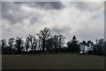
3
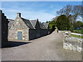
Castle entrance
Driveway into the restored Pitcullo Castle.
Image: © James Allan
Taken: 6 Apr 2015
0.04 miles
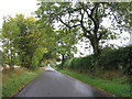
4
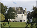
Pitcullo castle
Pitcullo Castle. Beautifully restored L plan tower house from the late 1500’s. Originally home to the Pitcairn family.
Image: © Jim Bain
Taken: 14 Oct 2005
0.06 miles
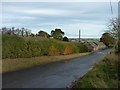
5
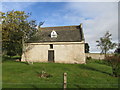
Dovecot at Pitcullo
The restored doocot near the entrance to Pitcullo Castle.
Image: © Scott Cormie
Taken: 29 Sep 2018
0.07 miles
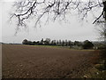
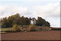
6
Pitcullo Castle
A restored castle sheltered by surrounding trees.
Image: © James Allan
Taken: 6 Apr 2015
0.10 miles
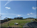
7
Pitcullo Castle
The restored castle at Pitcullo viewed from the south.
Image: © Scott Cormie
Taken: 29 Sep 2018
0.10 miles