IMAGES TAKEN NEAR TO
CUPAR, KY15 4NQ
Introduction
This page details the photographs taken nearby to KY15 4NQ by members of the Geograph project.
The Geograph project started in 2005 with the aim of publishing, organising and preserving representative images for every square kilometre of Great Britain, Ireland and the Isle of Man.

There are currently over 7.5m images from over14,400 individuals and you can help contribute to the project by visiting https://www.geograph.org.uk
Image Map
Images are licensed for reuse under creativecommons.org/licenses/by-sa/2.0
Notes
- Clicking on the map will re-center to the selected point.
- The higher the marker number, the further away the image location is from the centre of the postcode.
Image Listing (4 Images Found)
Images are licensed for reuse under creativecommons.org/licenses/by-sa/2.0
Image
Details
Distance
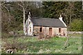
1
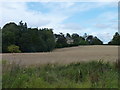
Over Rankeilour House
Nestling among trees opposite the Deer Centre.
Image: © James Allan
Taken: 18 Aug 2014
0.01 miles
2
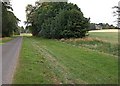
Over Rankeilour
Looking down the drive to the big house on the right of shot
Image: © Jim Bain
Taken: 25 Jul 2006
0.11 miles
4
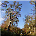
Wooded track
Public footpath leading north from Over Rankeilour, towards Fernie.
Image: © Jackie Proven
Taken: 3 Nov 2014
0.23 miles