IMAGES TAKEN NEAR TO
Tailabout Drive, CUPAR, KY15 4GW
Introduction
This page details the photographs taken nearby to Tailabout Drive, KY15 4GW by members of the Geograph project.
The Geograph project started in 2005 with the aim of publishing, organising and preserving representative images for every square kilometre of Great Britain, Ireland and the Isle of Man.

There are currently over 7.5m images from over14,400 individuals and you can help contribute to the project by visiting https://www.geograph.org.uk
Image Map
Images are licensed for reuse under creativecommons.org/licenses/by-sa/2.0
Notes
- Clicking on the map will re-center to the selected point.
- The higher the marker number, the further away the image location is from the centre of the postcode.
Image Listing (8 Images Found)
Images are licensed for reuse under creativecommons.org/licenses/by-sa/2.0
Image
Details
Distance
1
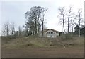
House on the Pitscottie Road
On the eastern outskirts of Cupar.
Image: © Russel Wills
Taken: 11 Apr 2013
0.07 miles
2
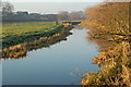
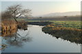
Eden haughs
Haugh lands by the Eden just to the east of the town.
Image: © Jim Bain
Taken: 19 Dec 2007
0.11 miles
3
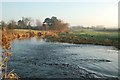
River Eden
Looking downstream towards the area around the beet factory silo.
Image: © Jim Bain
Taken: 19 Dec 2007
0.15 miles
4
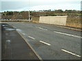
Railway bridge
The bridge that carries the B940 road across the main railway line from Edinburgh to Dundee
Image: © James Allan
Taken: 27 Feb 2006
0.15 miles
5
Eden haughs
Haugh lands to the south of the river, looking downstream towards Prestonhall.
Image: © Jim Bain
Taken: 19 Dec 2007
0.18 miles
6
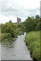
Eden East of Cupar
Looking down the Eden from the Cart Haugh bridge. The tower is the Beet factory on the Preston Hall Industrial estate.
Image: © Jim Bain
Taken: 9 Jul 2006
0.20 miles
7
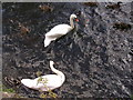
Swans on River Eden, Cupar
Mute Swans and Mallard.
Image: © Donald F Berry
Taken: 17 Sep 2004
0.21 miles
8
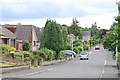
St Michaels Drive, Cupar
Modern housing on the eastern edge of Cupar. The road is on the alighnment of the old road to Tarvit House.
Image: © Jim Bain
Taken: 9 Jul 2006
0.23 miles