IMAGES TAKEN NEAR TO
Bonnygate, CUPAR, KY15 4BU
Introduction
This page details the photographs taken nearby to Bonnygate, KY15 4BU by members of the Geograph project.
The Geograph project started in 2005 with the aim of publishing, organising and preserving representative images for every square kilometre of Great Britain, Ireland and the Isle of Man.

There are currently over 7.5m images from over14,400 individuals and you can help contribute to the project by visiting https://www.geograph.org.uk
Image Map
Images are licensed for reuse under creativecommons.org/licenses/by-sa/2.0
Notes
- Clicking on the map will re-center to the selected point.
- The higher the marker number, the further away the image location is from the centre of the postcode.
Image Listing (190 Images Found)
Images are licensed for reuse under creativecommons.org/licenses/by-sa/2.0
Image
Details
Distance
1
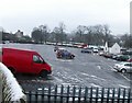
The Fluthers, Cupar
Now the main carpark for the town centre the Fluthers was once where the town gallows stood. The last public hanging took place here on June 5th 1852.
Image: © Jim Bain
Taken: 31 Dec 2005
0.02 miles
2
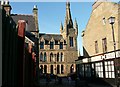
Duncan Institute Library, Cupar
Very fine building from Cupars past. Built in the 19c
Image: © Jim Bain
Taken: 10 Feb 2006
0.02 miles
3

Crossgate, Cupar
Looking down the Crossgate towards the market cross. The large imposing building on the left is the Duncan Institute. Built in 1870 with a legacy from a Miss Duncan of Edengrove to provide a library, lecture hall and museum for the working classes of Cupar, Dairsie and Kilconquhar Parishes. It's one of Cupar's finest buildings and was designed by John Milne
Image: © Jim Bain
Taken: 9 Jul 2006
0.02 miles
4
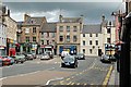
Crossgate, Cupar
Crossgate at its junction with the A91. The historic heart of the old town where the markets were held, space now devoted to the motor vehicle
Image: © Jim Bain
Taken: 9 Jul 2006
0.02 miles
5
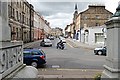
St Catherine Street, Cupar
From the war memorial looking up towards the Crossgate.
Image: © Jim Bain
Taken: 9 Jul 2006
0.02 miles
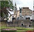
6
From Hood Park, Cupar
Looking past the war memorial up St Catherine Street with the spire of the Corn Exchange on the skyline. Hood park is much lower than the old town and is part of the River Eden's flood plain.
Image: © Jim Bain
Taken: 9 Jul 2006
0.02 miles
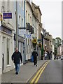
9
The Drookit Dug, Cupar
The pub is on Bonnygate.
Image: © Maigheach-gheal
Taken: 25 May 2008
0.03 miles
10
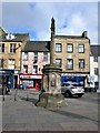
Mercat Cross, Cupar
The circular shaft dates from 1683 and was re-erected on 22nd June 1897 on a raised octagonal pedestal. It was resited in 2013 by Fife Council Transportation and Environmental Services to improve traffic flow. It is a Category B listed building. https://www.britishlistedbuildings.co.uk/200360021-mercat-cross-cupar#.Wr4pMjGWytU
Image: © G Laird
Taken: 29 Mar 2018
0.03 miles