IMAGES TAKEN NEAR TO
Dryburgh Road, KIRKCALDY, KY1 4PB
Introduction
This page details the photographs taken nearby to Dryburgh Road, KY1 4PB by members of the Geograph project.
The Geograph project started in 2005 with the aim of publishing, organising and preserving representative images for every square kilometre of Great Britain, Ireland and the Isle of Man.

There are currently over 7.5m images from over14,400 individuals and you can help contribute to the project by visiting https://www.geograph.org.uk
Image Map
Images are licensed for reuse under creativecommons.org/licenses/by-sa/2.0
Notes
- Clicking on the map will re-center to the selected point.
- The higher the marker number, the further away the image location is from the centre of the postcode.
Image Listing (18 Images Found)
Images are licensed for reuse under creativecommons.org/licenses/by-sa/2.0
Image
Details
Distance
1
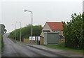
Minor road, Coaltown of Wemyss
The road runs to the A915. On the right is Lady Grosvenor Gait, a new housing estate which I suspect is named after a colliery.
Image: © Richard Webb
Taken: 29 May 2012
0.08 miles
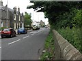
2
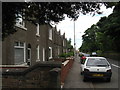
A row of houses near Coaltown of Wemyss
Sitting adjacent to the A955 road.
Image: © James Denham
Taken: 22 Jun 2009
0.08 miles
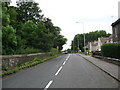
5
The A955 at Coaltown of Wemyss
Looking north-east.
Image: © M J Richardson
Taken: 22 Jun 2009
0.11 miles
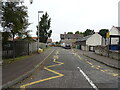
6
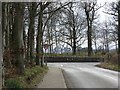
T-junction on A955 at Coaltown of Wemyss
Image: © Becky Williamson
Taken: 29 Mar 2020
0.12 miles
7
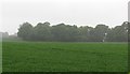
Arable land, Coaltown of Wemyss
Looking towards Bowhouse Strip.
Image: © Richard Webb
Taken: 30 May 2012
0.12 miles
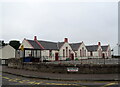
9
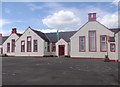
Primary School, Coaltown of Wemyss
Girl's entrance from the playground. The school stands by the Main Road (A955).
Image: © Stanley Howe
Taken: 14 May 2014
0.13 miles
10
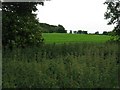
View from the road at Coaltown
A good crop of nettles, and a cereal field beyond.
Image: © M J Richardson
Taken: 22 Jun 2009
0.17 miles