IMAGES TAKEN NEAR TO
Main Street, KIRKCALDY, KY1 4NN
Introduction
This page details the photographs taken nearby to Main Street, KY1 4NN by members of the Geograph project.
The Geograph project started in 2005 with the aim of publishing, organising and preserving representative images for every square kilometre of Great Britain, Ireland and the Isle of Man.

There are currently over 7.5m images from over14,400 individuals and you can help contribute to the project by visiting https://www.geograph.org.uk
Image Map
Images are licensed for reuse under creativecommons.org/licenses/by-sa/2.0
Notes
- Clicking on the map will re-center to the selected point.
- The higher the marker number, the further away the image location is from the centre of the postcode.
Image Listing (18 Images Found)
Images are licensed for reuse under creativecommons.org/licenses/by-sa/2.0
Image
Details
Distance
1
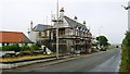
The Earl David Hotel
Situated on the A955 at Coaltown of Wemyss this category 'C' listed building is now permanently closed as a hotel and is being redeveloped into residential flats https://www.geograph.org.uk/photo/4153164
Image: © Bill Kasman
Taken: 18 Aug 2020
0.01 miles
2
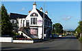
The Earl David Hotel
Located along the A955 at Coaltown of Wemyss.
The hotel was built in 1911 and named after David, 2nd Earl of Wemyss (1610 to 1679) upon whose estate it stands.
Image: © Mat Fascione
Taken: 22 Jul 2019
0.02 miles
3
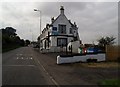
The Earl David, Coaltown of Wemyss
Now closed, this building first began serving drinks in 1911 when it was opened as a "Goth pub". Essentially a Goth was a cooperative whereby the profits were ploughed back into the local community, and it was also envisaged that this type of business model would encourage sensible drinking. Its rather curious name derives from the Swedish city of Gothenburg where this type of business venture first began.
Image: © Euan Nelson
Taken: 6 Sep 2014
0.04 miles
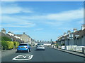
4
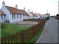
Lochhead Crescent
A row of modernised cottages originally built to accommodate the families of miners working in the coal mines around Coaltown of Wemyss
Image: © James Allan
Taken: 2 Mar 2007
0.05 miles
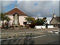
5
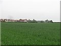
Arable land, Coaltown of Wemyss
View towards the village.
Image: © Richard Webb
Taken: 30 May 2012
0.09 miles
6
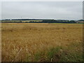
Cereal crop near Coaltown of Wemyss
Off the A955.
Image: © JThomas
Taken: 21 Jul 2021
0.10 miles
7
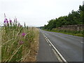
A955 leaving, Coaltown of Wemyss
Towards East Wemyss
Image: © JThomas
Taken: 21 Jul 2021
0.12 miles
9
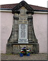
War Memorial, Miners Welfare Institute, Coaltown of Wemyss
Image: © JThomas
Taken: 21 Jul 2021
0.20 miles
10
Miners' Welfare Institute and War Memorial, Coaltown of Wemyss
Formerly housing the Miners' Welfare Institute in Coaltown of Wemyss, this building dates from 1923 and was designed by the architect, Alexander Tod.
Image: © Euan Nelson
Taken: 6 Sep 2014
0.20 miles