IMAGES TAKEN NEAR TO
Walker Drive, KY1 4EX
Introduction
This page details the photographs taken nearby to Walker Drive, KY1 4EX by members of the Geograph project.
The Geograph project started in 2005 with the aim of publishing, organising and preserving representative images for every square kilometre of Great Britain, Ireland and the Isle of Man.

There are currently over 7.5m images from over14,400 individuals and you can help contribute to the project by visiting https://www.geograph.org.uk
Image Map
Images are licensed for reuse under creativecommons.org/licenses/by-sa/2.0
Notes
- Clicking on the map will re-center to the selected point.
- The higher the marker number, the further away the image location is from the centre of the postcode.
Image Listing (25 Images Found)
Images are licensed for reuse under creativecommons.org/licenses/by-sa/2.0
Image
Details
Distance
4
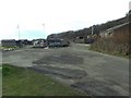
Clear up in progress
The former scrap yard alongside the East Wemyss angling club is gradually disappearing.
Image: © James Allan
Taken: 17 Mar 2014
0.12 miles
5
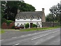
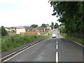
Roadside house between Coaltown and East Wemyss
Marked on the map as East Lodge, but more substantial than the usual lodges.
Image: © M J Richardson
Taken: 22 Jun 2009
0.13 miles
6
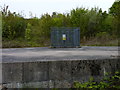
Gas vent
The Fife Coastal Path crosses the site formerly occupied by the Michael Colliery and this concrete slab with a mine gas vent fenced off in its centre is evidence of that. The Michael Colliery, Scotland's biggest and deepest coal mine, opened in 1897 and closed in September 1967 after a seam of coal ignited 1800 feet below the ground killing nine men. A monument was erected in East Wemyss in 1992 on the 25th anniversary of the fatal fire. Three years later, the pithead gear was demolished and little remains to remind one of this once-thriving colliery.
Image: © James Allan
Taken: 21 May 2012
0.14 miles
7
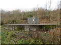
Mine gas vent
At the site of the Michael Colliery which closed in 1967 after a seam of coal ignited, killing 9 men.
Image: © Graham Hogg
Taken: 18 Nov 2018
0.14 miles
8
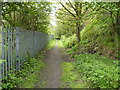
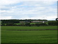
No sign of the coast
This section of the Fife Coastal Path to the west of East Wemyss affords little view in either direction.
Image: © James Allan
Taken: 21 May 2012
0.16 miles
9
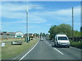
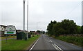
A955 Main Road at East Wemyss village boundary
Image: © Colin Pyle
Taken: 11 Jun 2015
0.16 miles
10
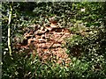
Red sandstone
A weathered exposure of red sandstone alongside the Fife Coastal path between West and East Wemyss.
Image: © James Allan
Taken: 24 Aug 2009
0.17 miles