IMAGES TAKEN NEAR TO
Strathore Road, KIRKCALDY, KY1 4DX
Introduction
This page details the photographs taken nearby to Strathore Road, KY1 4DX by members of the Geograph project.
The Geograph project started in 2005 with the aim of publishing, organising and preserving representative images for every square kilometre of Great Britain, Ireland and the Isle of Man.

There are currently over 7.5m images from over14,400 individuals and you can help contribute to the project by visiting https://www.geograph.org.uk
Image Map
Images are licensed for reuse under creativecommons.org/licenses/by-sa/2.0
Notes
- Clicking on the map will re-center to the selected point.
- The higher the marker number, the further away the image location is from the centre of the postcode.
Image Listing (7 Images Found)
Images are licensed for reuse under creativecommons.org/licenses/by-sa/2.0
Image
Details
Distance
1
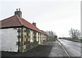
Strathore Cottages, Strathore Road, Thornton
There is an Ordnance Survey benchmark on one of these cottages. See Image
Image: © Becky Williamson
Taken: 28 Dec 2020
0.06 miles
2
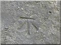
Benchmark on Strathore Cottages, Thornton
Ordnance Survey benchmark, described on database at https://www.bench-marks.org.uk/bm138290. See also Image]
.
Image: © Becky Williamson
Taken: 28 Dec 2020
0.07 miles
3
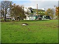
Farm plant at Strathore
Possibly compounding food for the large number of animal rearing houses in the vicinity - pigs, or perhaps chickens.
Image: © M J Richardson
Taken: 31 Oct 2009
0.12 miles
4
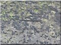
Benchmark on wall, Strathore Road, Thornton
Ordnance Survey benchmark, described on database at https://www.bench-marks.org.uk/bm138294. See also Image
Image: © Becky Williamson
Taken: 28 Dec 2020
0.14 miles
5
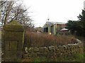
Wall on Strathore Road, Thornton
There is an Ordnance Survey benchmark on this wall. See Image
Image: © Becky Williamson
Taken: 28 Dec 2020
0.14 miles
6
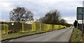
Security fencing
In Strathore Road, Thornton, Fife this brightly-coloured security fencing runs along the south side of the road for about 300 metres.
Image: © Bill Kasman
Taken: 8 Apr 2018
0.14 miles
7
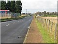
Strathore Road
A long straight country road, farmland to right and much old railway and other industrial land associated with earlier mining on the left.
Image: © M J Richardson
Taken: 31 Oct 2009
0.22 miles