IMAGES TAKEN NEAR TO
Strathmiglo, CUPAR, KY14 7RU
Introduction
This page details the photographs taken nearby to KY14 7RU by members of the Geograph project.
The Geograph project started in 2005 with the aim of publishing, organising and preserving representative images for every square kilometre of Great Britain, Ireland and the Isle of Man.

There are currently over 7.5m images from over14,400 individuals and you can help contribute to the project by visiting https://www.geograph.org.uk
Image Map
Images are licensed for reuse under creativecommons.org/licenses/by-sa/2.0
Notes
- Clicking on the map will re-center to the selected point.
- The higher the marker number, the further away the image location is from the centre of the postcode.
Image Listing (8 Images Found)
Images are licensed for reuse under creativecommons.org/licenses/by-sa/2.0
Image
Details
Distance
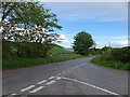
1
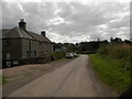
Minor road passing off-road driving centre at Glentarkie
Image: © Douglas Nelson
Taken: 27 Aug 2016
0.11 miles
2
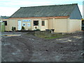
Scottish Off-Road Driving Centre
The 'Mad on Mud' activity seems to start right there in the car park!
Image: © James Allan
Taken: 21 Jan 2006
0.12 miles
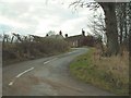
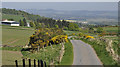
4
Road to Abernethy, Glentarkie
The road on the left serves the off road driving centre on Beins Law.
Image: © Richard Webb
Taken: 17 Feb 2022
0.16 miles
6
The road to Pittuncarty
Typical of the higher ground which lies north of the Howe of Fife.
Image: © Iain A Robertson
Taken: 1 May 2011
0.21 miles
7
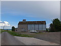
Gas tank and farm building at Pittuncarty
Image: © Alpin Stewart
Taken: 22 May 2016
0.22 miles
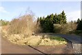
8
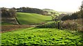
Pond below Big Garret
A dammed burn below a small plantation called Big Garret.
Image: © Richard Webb
Taken: 22 Nov 2009
0.23 miles