IMAGES TAKEN NEAR TO
Glebe Park, CUPAR, KY14 7QF
Introduction
This page details the photographs taken nearby to Glebe Park, KY14 7QF by members of the Geograph project.
The Geograph project started in 2005 with the aim of publishing, organising and preserving representative images for every square kilometre of Great Britain, Ireland and the Isle of Man.

There are currently over 7.5m images from over14,400 individuals and you can help contribute to the project by visiting https://www.geograph.org.uk
Image Map (Loading...)


Getting Data...Please wait
Leaflet Map data © OpenStreetMap
Images are licensed for reuse under creativecommons.org/licenses/by-sa/2.0
Notes
- Clicking on the map will re-center to the selected point.
- The higher the marker number, the further away the image location is from the centre of the postcode.
Image Listing (40 Images Found)
Images are licensed for reuse under creativecommons.org/licenses/by-sa/2.0
Image
Details
Distance
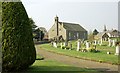
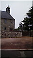
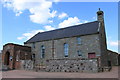
2
Strathmiglo Kirk
Set in Kirk Wynd in the village at the heart of rural Fife.
Image: © James Denham
Taken: 13 Sep 2008
0.07 miles
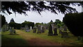
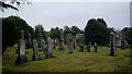
4
Church, Strathmiglo
Church and burial grounds by the eastern edge of the village.
Image: © Jim Bain
Taken: 15 Apr 2007
0.07 miles
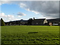
7
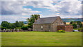
Edenshead and Strathmiglo Parish Church
Image: © Peter Moore
Taken: 29 Jul 2022
0.09 miles
8
Belfry on Edenshead and Strathmiglo Parish Church
Image: © Patrick
Taken: 8 Jun 2022
0.09 miles
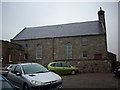
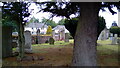
9
Edenshead and Strathmiglo Parish Church
Parish church viewed from car park.
Image: © edward mcmaihin
Taken: 3 Jul 2011
0.09 miles
10
Strathmiglo Kirk
From the junction of the High Street with Kirk Wynd.
Image: © Stanley Howe
Taken: 17 May 2014
0.09 miles