IMAGES TAKEN NEAR TO
Burnside Terrace, CUPAR, KY14 7DE
Introduction
This page details the photographs taken nearby to Burnside Terrace, KY14 7DE by members of the Geograph project.
The Geograph project started in 2005 with the aim of publishing, organising and preserving representative images for every square kilometre of Great Britain, Ireland and the Isle of Man.

There are currently over 7.5m images from over14,400 individuals and you can help contribute to the project by visiting https://www.geograph.org.uk
Image Map
Images are licensed for reuse under creativecommons.org/licenses/by-sa/2.0
Notes
- Clicking on the map will re-center to the selected point.
- The higher the marker number, the further away the image location is from the centre of the postcode.
Image Listing (76 Images Found)
Images are licensed for reuse under creativecommons.org/licenses/by-sa/2.0
Image
Details
Distance
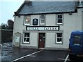
2
Cycle Tavern, Auchtermuchty
Newly painted, previous image: Image
Image: © Richard Webb
Taken: 17 Jul 2013
0.03 miles
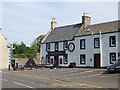
3
Cycle Tavern
On Burnside in Auchtermuchty.
Image: © Russel Wills
Taken: 29 May 2019
0.05 miles
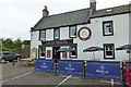
4
Cycle Tavern, Auchtermuchty
On the corner of Burnside (B936) and Bondgate.
Image: © Stanley Howe
Taken: 17 May 2014
0.05 miles
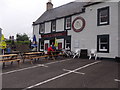
5
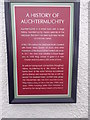
A History of Auchtermuchty
Summarised in a plaque by the door of the Cycle Tavern.
Image: © Stanley Howe
Taken: 17 May 2014
0.05 miles
6
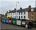
Village recycling centre
Red for cans and plastics, blue for paper and cardboard and a choice of three colours (green, white and brown) for glass.
Image: © Bill Harrison
Taken: 16 Apr 2023
0.07 miles
7
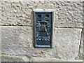
Ordnance Survey Flush Bracket S5085
This bracket can be found on the wall of a building at Auchtermuchty Primary School.
The benchmark has a recorded height of 60.1533 metres above sea level.
For more detail see : https://www.bench-marks.org.uk/bm19377
Image: © Peter Wood
Taken: 14 May 2021
0.08 miles
8
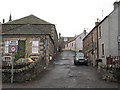
Auchtermuchty
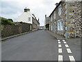
A weak bridge off Burnside.
Image: © Richard Webb
Taken: 9 Nov 2008
0.08 miles
9
High Street, Auchtermuchty
Looking north-westward.
Image: © Peter Wood
Taken: 14 May 2021
0.08 miles
10
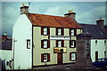
The Boar's Head, Auchtermuchty
Large and historic inn (1738) at the centre of the village with the war memorial outside its door. Renamed (2012) it was called the Forest Hills Hotel but has since reverted to The Boar's Head.
http://en.wikipedia.org/wiki/Auchtermuchty
http://www.auchtermuchty-fife.50megs.com/
Image: © Colin Smith
Taken: 1 Aug 1984
0.08 miles