IMAGES TAKEN NEAR TO
Millflat, CUPAR, KY14 7BQ
Introduction
This page details the photographs taken nearby to Millflat, KY14 7BQ by members of the Geograph project.
The Geograph project started in 2005 with the aim of publishing, organising and preserving representative images for every square kilometre of Great Britain, Ireland and the Isle of Man.

There are currently over 7.5m images from over14,400 individuals and you can help contribute to the project by visiting https://www.geograph.org.uk
Image Map (Loading...)


Getting Data...Please wait
Leaflet Map data © OpenStreetMap
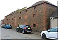
Images are licensed for reuse under creativecommons.org/licenses/by-sa/2.0
Notes
- Clicking on the map will re-center to the selected point.
- The higher the marker number, the further away the image location is from the centre of the postcode.
Image Listing (54 Images Found)
Images are licensed for reuse under creativecommons.org/licenses/by-sa/2.0
Image
Details
Distance
1
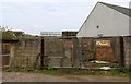
Auchtermuchty Distillery
This used to be a goods entrance to Auchtermuchty Distillery. The white building is a private house but the old distillery roof can be seen.
Image: © Bill Kasman
Taken: 17 Apr 2019
0.16 miles
3
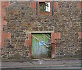
Auchtermuchty Distillery
This is one of two doors in what was a warehouse for Auchtermuchty Distillery.
Image: © Bill Kasman
Taken: 17 Apr 2019
0.17 miles
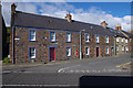
4
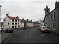
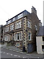
Guides Hall
High Street, Auchtermuchty. See http://canmoremapping.rcahms.gov.uk/index.php?action=do_details&cache_name=aWRudW1saW5rLDIyMzEwN19zZWFyY2h0eXBlLGFkdmFuY2VkX29yYQ==&set=0&list_z=0&numlink=223107
Image: © Stanley Howe
Taken: 17 May 2014
0.17 miles
5
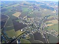
Auchtermuchty from the air
Looking north-west across the town.
Image: © James Allan
Taken: 20 Feb 2010
0.17 miles
7
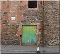
Auchtermuchty Distillery
This is one of two doors in what was a warehouse for Auchtermuchty Distillery.
Image: © Bill Kasman
Taken: 17 Apr 2019
0.17 miles
8
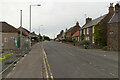
Low Road, Auchtermuchty
At the junction with Crosshills.
Image: © Mark Anderson
Taken: 15 Aug 2021
0.17 miles
9
Auchtermuchty Distillery
This building is the main surviving part of what was Auchtermuchty Distillery which was also known as Stratheden Distillery http://www.lost-distillery.com/pages/stratheden
Image: © Bill Kasman
Taken: 17 Apr 2019
0.17 miles
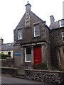
10
No. 31 High Street, Auchtermuchty
An imposing house on the High Street. There is an Ordnance Survey bench mark on the east side of the building.
Image: © Maigheach-gheal
Taken: 13 Oct 2010
0.18 miles