IMAGES TAKEN NEAR TO
Kilndales Terrace, CUPAR, KY14 6HY
Introduction
This page details the photographs taken nearby to Kilndales Terrace, KY14 6HY by members of the Geograph project.
The Geograph project started in 2005 with the aim of publishing, organising and preserving representative images for every square kilometre of Great Britain, Ireland and the Isle of Man.

There are currently over 7.5m images from over14,400 individuals and you can help contribute to the project by visiting https://www.geograph.org.uk
Image Map
Images are licensed for reuse under creativecommons.org/licenses/by-sa/2.0
Notes
- Clicking on the map will re-center to the selected point.
- The higher the marker number, the further away the image location is from the centre of the postcode.
Image Listing (19 Images Found)
Images are licensed for reuse under creativecommons.org/licenses/by-sa/2.0
Image
Details
Distance
1
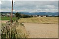
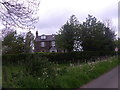
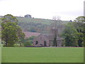
Towards Grange Of Lindores
Grange of Lindores is one of Fife's attractive and well-maintained little hamlets.
Image: © Mary and Angus Hogg
Taken: 5 Sep 2008
0.02 miles
3
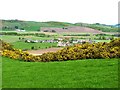
Grange of Lindores
Seen from the hill south west of the village.
Image: © James Allan
Taken: 25 Apr 2011
0.04 miles
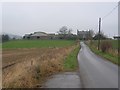
4
Entering Grange of Lindores from the south
On a minor road from Berryhill; the 30mph speed limit sign applies on the village streets ahead.
Image: © Stanley Howe
Taken: 17 May 2014
0.09 miles
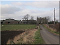
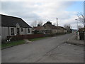
6
Grange of Lindores
Farm on the southern side of the village
Image: © Richard Webb
Taken: 12 Feb 2006
0.12 miles
7
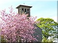
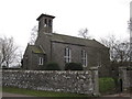
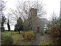
Unusual bell tower
The Kirk of Abdie and Dunbog sports a bell tower that looks more Italian than Scottish.
Image: © James Allan
Taken: 25 Apr 2011
0.13 miles
9
Kirk of Abdie and Dunbog
Viewed from Grange of Lindores.
Image: © Stanley Howe
Taken: 17 May 2014
0.15 miles