IMAGES TAKEN NEAR TO
Newburgh, CUPAR, KY14 6HP
Introduction
This page details the photographs taken nearby to KY14 6HP by members of the Geograph project.
The Geograph project started in 2005 with the aim of publishing, organising and preserving representative images for every square kilometre of Great Britain, Ireland and the Isle of Man.

There are currently over 7.5m images from over14,400 individuals and you can help contribute to the project by visiting https://www.geograph.org.uk
Image Map
Images are licensed for reuse under creativecommons.org/licenses/by-sa/2.0
Notes
- Clicking on the map will re-center to the selected point.
- The higher the marker number, the further away the image location is from the centre of the postcode.
Image Listing (9 Images Found)
Images are licensed for reuse under creativecommons.org/licenses/by-sa/2.0
Image
Details
Distance
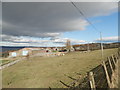
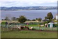
2
The fields of East Fisk
With farm buildings and the River Tay beyond.
Image: © James Denham
Taken: 31 Jul 2012
0.09 miles
3
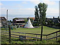
Wigwam at East Flisk
Wigwam in the grounds of East Flisk farm.
Image: © Scott Cormie
Taken: 1 Jul 2018
0.09 miles
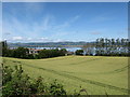
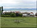
4
East Flisk Farm
The fields run down to the Firth of Tay.
Image: © David Purchase
Taken: 6 Jun 2018
0.10 miles
5
Garden and pets at East Flisk
The River Tay beyond.
Image: © Russel Wills
Taken: 21 Sep 2018
0.11 miles
6
East Flisk Farm
Firth of Tay in the background.
Image: © James Allan
Taken: 10 Jul 2006
0.12 miles
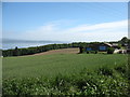
7
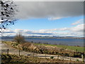
Farm land at East Flisk
Overlooking the Tay towards the hills of Perthshire
Image: © Douglas Nelson
Taken: 16 Mar 2014
0.19 miles
8
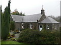
Fliskwood Cottage
On the edge of Flisk Wood.
Image: © Russel Wills
Taken: 6 Nov 2009
0.23 miles
9
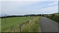
East Flisk
A road running above the southern shore of the Tay estuary.
Image: © Richard Webb
Taken: 17 Jul 2013
0.25 miles