IMAGES TAKEN NEAR TO
Clinton Street, CUPAR, KY14 6DP
Introduction
This page details the photographs taken nearby to Clinton Street, KY14 6DP by members of the Geograph project.
The Geograph project started in 2005 with the aim of publishing, organising and preserving representative images for every square kilometre of Great Britain, Ireland and the Isle of Man.

There are currently over 7.5m images from over14,400 individuals and you can help contribute to the project by visiting https://www.geograph.org.uk
Image Map (Loading...)


Getting Data...Please wait
Leaflet Map data © OpenStreetMap
Images are licensed for reuse under creativecommons.org/licenses/by-sa/2.0
Notes
- Clicking on the map will re-center to the selected point.
- The higher the marker number, the further away the image location is from the centre of the postcode.
Image Listing (55 Images Found)
Images are licensed for reuse under creativecommons.org/licenses/by-sa/2.0
Image
Details
Distance
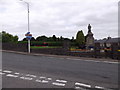
1
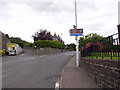
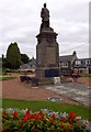
A road junction in Newburgh (Fife)
Where Woodriffe Road (NCR776) departs Abernethy Road (NCR779/A913), opposite the War Memorial.
Image: © Stanley Howe
Taken: 12 Aug 2015
0.03 miles
2
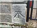
Ordnance Survey Cut Mark
This mark can be found on the wall of the URC Church in Clinton Street, Newburgh.
The benchmark has a recorded height of 28.7 metres above sea level.
For more detail see : https://www.bench-marks.org.uk/bm150915
Image: © Peter Wood
Taken: 14 May 2021
0.03 miles
3

United Reformed Church, Newburgh (Fife)
The date stone over the windows indicates it was built in 1880; the scaffolding denotes it was undergoing a face-lift in 2015.
Image: © Stanley Howe
Taken: 12 Aug 2015
0.03 miles
5
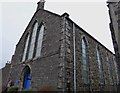
United Reformed Church
Church in Clinton St, just off the High Street at the western edge of Newburgh.
Image: © Jackie Proven
Taken: 5 Jan 2015
0.03 miles
6
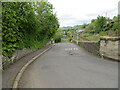
Woodliffe Road in Newburgh
Looking north-eastward.
Image: © Peter Wood
Taken: 14 May 2021
0.04 miles
7
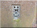
Ordnance Survey Flush Bracket G643
This bracket can be found on the roadside wall of a house in Clinton Street, Newburgh.
The benchmark has a recorded height of 26.2746 metres above sea level.
For more detail see : https://www.bench-marks.org.uk/bm10705
Image: © Peter Wood
Taken: 14 May 2021
0.05 miles
9
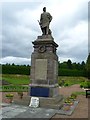
War Memorial, Newburgh (Fife)
Off Abernethy Road.
Image: © Stanley Howe
Taken: 12 Aug 2015
0.05 miles