IMAGES TAKEN NEAR TO
Rosslyn Gardens, KIRKCALDY, KY1 3BF
Introduction
This page details the photographs taken nearby to Rosslyn Gardens, KY1 3BF by members of the Geograph project.
The Geograph project started in 2005 with the aim of publishing, organising and preserving representative images for every square kilometre of Great Britain, Ireland and the Isle of Man.

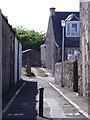
There are currently over 7.5m images from over14,400 individuals and you can help contribute to the project by visiting https://www.geograph.org.uk
Image Map
Images are licensed for reuse under creativecommons.org/licenses/by-sa/2.0
Notes
- Clicking on the map will re-center to the selected point.
- The higher the marker number, the further away the image location is from the centre of the postcode.
Image Listing (20 Images Found)
Images are licensed for reuse under creativecommons.org/licenses/by-sa/2.0
Image
Details
Distance
1
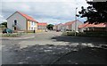
New housing development, Kirkcaldy
Rosslyn Gardens is a newly-built development near the outskirts of Kirkcaldy.
Image: © Bill Kasman
Taken: 30 Jul 2017
0.01 miles
2
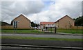
New housing development, Kirkcaldy
Rosslyn Gardens is a newly-built housing development near the outskirts of Kirkcaldy seen here over the dual carriageway of Rossyln Street (A921).
Image: © Bill Kasman
Taken: 30 Jul 2017
0.02 miles
3
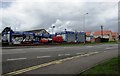
Car Care Centre, Kirkcaldy
This car wash and service centre is on Rosslyn Street (A921) as it leaves Kirkcaldy. The red-roofed houses on the right is the new housing development of Rossyln Gardens Image
Image: © Bill Kasman
Taken: 30 Jul 2017
0.05 miles
4
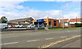
Bakers retail shop
Off Rosslyn Street (A921) Kirkcaldy, this branch of Stephens Bakers opened in April 2019. The design of the building will be common to all Stephens new retail shops. This site was previously occupied by a car care centre https://www.geograph.org.uk/photo/5480543
Image: © Bill Kasman
Taken: 24 Aug 2020
0.05 miles
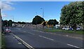
5
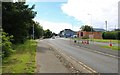
Rosslyn Street, Kirkcaldy
As it enters Kirkcaldy.
Image: © Bill Kasman
Taken: 24 Aug 2020
0.06 miles
6
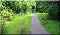
Footpath, Kirkcaldy
Running parallel to Randolph Road (A915) on the outskirts of Kirkcaldy this footpath is well-used by cyclists and joggers.
Image: © Bill Kasman
Taken: 24 Aug 2020
0.07 miles
7
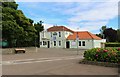
Pub restaurant for lease
In Kirkcaldy this once-popular pub restaurant is closed and up for lease.
Image: © Bill Kasman
Taken: 24 Aug 2020
0.09 miles
8
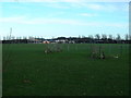
Kirkcaldy : Randolph Playing Fields
The fencing in the photo demarcates the greyhound track.
Image: © Kevin O'Kane
Taken: 21 Dec 2005
0.10 miles
9
Demolition site, Kirkcaldy
This building, previously a branch of 'Terry's Tyres and Autocare', at the junction of Windmill Road and Rosslyn Street, has been demolished.
Image: © Bill Kasman
Taken: 14 Jul 2021
0.14 miles